|
|
|
 |
|
| Monday 31 December |
17.84
mi |
28.71
km |
|
|
|
|
| Home to Warsash Ferry |
12.47
mi |
20.07
km |
|
| Via St Denys Road, Cobden Bridge,
Bullar Road, Bitterne Road, Northam
Bridge, Chapel, Itchen Bridge,
Woolston, Portsmouth Road, Old
Netley, Pound Road, Hamble Lane,
Lowford, Lower Swanwick, Swanwick
Shore Road, Universal Marina,
river path, Passage Lane, Shore
Road, Warsash village, Newtown
Road, Hook Park Road, local nature
reserve, beach, river path and
Shore Road. |
|
| Hamble Quay to Royal Victoria
Country Park |
2.91
mi |
4.68
km |
|
| Up to Hamble Square then down
School Lane to Hamble Point, along
the shore and round the country
park to the cafe. |
|
| Royal Victoria Country
Park to Netley Station |
2.46
mi |
3.96
km |
|
| Out to Hamble Lane and Hamble
station then Hound Road, Hound
Way, Station Road and Netley station
for the train home. |
|
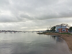
| A cloudy day, mild with a chilly
breeze along Hamble Shore. |
|
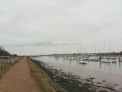
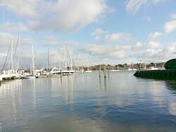
| Photo: The
path along the River Hamble. |
|
|
|
|
|
 |
|
| Saturday 29 December |
19.55
mi |
31.46
km |
|
|
|
|
| Home to Warsash Ferry |
15.25
mi |
24.54
km |
|
| Via St Denys Road, Cobden Bridge,
Bullar Road, Bitterne Road, Northam
Bridge, Chapel, Itchen Bridge,
Woolston, Portsmouth Road, Old
Netley, Pound Road, Hamble Lane,
Lowford, Lower Swanwick, Park
Gate, Titchfield and Warsash village
(non-stop). |
|
| Hamble Quay to Royal Victoria
Country Park |
2.19
mi |
3.52
km |
|
| Up to Hamble Square then Hamble
Lane, Coach Road (Coronation Parade),
Westfield Common, down to the
shore and round the country park
to the cafe. |
|
| Royal Victoria Country
Park to Netley Station |
2.11
mi |
3.40
km |
|
| Out to Hound Road, Hamble Lane
and Hamble station then along
the Rail Trail footpaths to The
Badgers and Netley station for
the train home. |
|
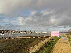
| Mostly cloudy, a chilly breeze
near the water but otherwise fairly
mild. |
|
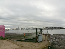
| Photo: Warsash
ferry pontoon and hard. |
|
|
|
|
|
 |
|
| Thursday 27 December |
15.84
mi |
25.49
km |
|
|
|
|
| Home to Warsash Village |
10.00
mi |
16.09
km |
|
| Via St Denys Road, Cobden Bridge,
Bullar Road, Bitterne Road, Northam
Bridge, Chapel, Itchen Bridge,
Woolston, Portsmouth Road, Old
Netley, Pound Road, Hamble Lane,
Lowford, Lower Swanwick and Sarisbury
Green. |
|
| Warsash Village to Warsash
Ferry |
0.53
mi |
0.85
km |
|
| Down Shore Road to the waterfront
for a refreshment break, then
along to the ferry pontoon. |
|
| Hamble Quay to Royal Victoria
Country Park |
2.85
mi |
4.59
km |
|
| Up Green Lane, down School Lane
to Hamble Point, along the shore
to the country park and round
to the cafe for another break. |
|
| Royal Victoria Country
Park to Netley Station |
2.46
mi |
3.96
km |
|
| Out to Hamble Lane (recreation
ground), along Hamble Lane to
Hamble station and Hound Road,
then Hound Road, Hound Way and
Station Road to Netley station
for the train home. |
|
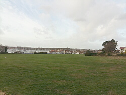
| Cold and grey early, sunny later. |
|
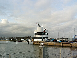
| Photo: The
harbour, Shore Road, Warsash. |
|
|
|
|
|
 |
|
| Saturday 22 December |
19.31
mi |
31.08
km |
|
|
|
|
| Home to Warsash Village |
10.01
mi |
16.11
km |
|
| Via St Denys Road, Cobden Bridge,
Bullar Road, Bitterne Road, Northam
Bridge, Chapel, Itchen Bridge,
Woolston, Portsmouth Road, Old
Netley, Pound Road, Hamble Lane,
Lowford, Lower Swanwick and Sarisbury
Green. |
|
| Warsash Village to Warsash
Ferry |
0.54
mi |
0.87
km |
|
| Down Shore Road to the waterfront
for a refreshment break, then
along to the ferry pontoon. |
|
| Hamble Quay to Royal Victoria
Country Park |
2.78
mi |
4.47
km |
|
| Up to The Square, along Hamble
Lane and Hound Road then the footpath
to the cafe in the park. |
|
| Royal Victoria Country
Park to Home |
5.98
mi |
9.62
km |
|
| After a break at the cafe, out
to Netley Abbey, Weston Shore,
Woolston, Peartree, Athelstan
Road, Bullar Road, Cobden Bridge,
St Denys Road and home. |
|
| Sunny intervals with a cold
wind. |
|
| Photo: The
cafe at Hamble Quay. |
|
|
|
|
|
 |
|
| Thursday 20 December |
15.38
mi |
24.75
km |
|
|
|
|
| Home to Warsash Village |
10.03
mi |
16.14
km |
|
| Via St Denys Road, Cobden Bridge,
Bullar Road, Bitterne Road, Northam
Bridge, Chapel, Itchen Bridge,
Woolston, Portsmouth Road, Old
Netley, Pound Road, Hamble Lane,
Lowford, Lower Swanwick and Sarisbury
Green. |
|
| Warsash Village to Warsash
Ferry |
0.53
mi |
0.85
km |
|
| Down Shore Road to the waterfront
for a refreshment break, then
along to the ferry pontoon. |
|
| Hamble Quay to Royal Victoria
Country Park |
4.26
mi |
6.86
km |
|
| Up to The Square, along Hamble
Lane, Hound Road, Hound Way, Station
Road, Victoria Road (Netley),
along the shore road to the pier
in the Royal Victoria Country
Park and round the park to the
cafe. |
|
| Royal Victoria Country
Park to Netley Station |
0.56
mi |
0.90
km |
|
| After a break at the cafe, out
to Hound Road, The Badgers and
Netley station. |
|
| Mostly sunny but later clouded
over, becoming windy with some
rain. |
|
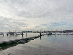
| Photo: The
ferry pontoon, Warsash. |
|
|
|
|
|
 |
|
| Monday 17 December |
15.88
mi |
25.56
km |
|
|
|
|
| Home to Warsash Village |
10.02
mi |
16.13
km |
|
| Via St Denys Road, Cobden Bridge,
Bullar Road, Bitterne Road, Northam
Bridge, Chapel, Itchen Bridge,
Woolston, Portsmouth Road, Old
Netley, Pound Road, Hamble Lane,
Lowford, Lower Swanwick and Sarisbury
Green. |
|
| Warsash Village to Warsash
Ferry |
0.70
mi |
1.13
km |
|
| Down Newtown Road and across
Strawberry Field to the waterfront
for a refreshment break, then
along to the ferry pontoon. |
|
| Hamble Quay to Royal Victoria
Country Park |
2.95
mi |
4.75
km |
|
| Up to The Square, along School
Lane to Hamble Point and along
the shore to the country park.
Round the park to the cafe. |
|
| Royal Victoria Country
Park to Netley Station |
2.21
mi |
3.56
km |
|
| After a break at the cafe, out
to Hound Road, Hamble Lane and
Hamble station then along the
Rail Trail footpaths to Hound
Road, The Badgers and Netley station. |
|
| Quite sunny at first, cloudy
later. Mild. |
|
| Photo: Strawberry
Field, Warsash. |
|
|
|
|
|
 |
|
| Friday 14 December |
14.38
mi |
23.14
km |
|
|
|
|
| Home to Warsash Village |
10.03
mi |
16.14
km |
|
| Via St Denys Road, Cobden Bridge,
Bullar Road, Bitterne Road, Northam
Bridge, Chapel, Itchen Bridge,
Woolston, Portsmouth Road, Old
Netley, Pound Road, Hamble Lane,
Lowford, Lower Swanwick and Sarisbury
Green. |
|
| Warsash Village to Warsash
Ferry |
0.59
mi |
0.95
km |
|
| Down Shore Road to the waterfront
for a short break, then along
to the ferry pontoon. |
|
| Hamble Quay to Royal Victoria
Country Park |
3.78
mi |
6.08
km |
|
| Up to The Square, along Hamble
Lane, Hound Road, Hound Way, Station
Road, Victoria Road (Netley) and
round the park to the cafe. |
|
| Royal Victoria Country
Park to Netley Station |
0.57
mi |
0.92
km |
|
| After a break at the cafe, out
to Hound Road, The Badgers and
Netley station. |
|
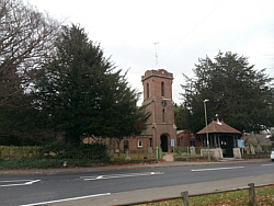
| Started sunny but soon clouded
over with a cold wind. |
|
| Photo: St
Paul's church, Sarisbury Green. |
|
|
|
|
|
 |
|
| Tuesday 11 December |
14.49
mi |
23.32
km |
|
|
|
|
| Home to Warsash Village |
10.02
mi |
16.13
km |
|
| Via St Denys Road, Cobden Bridge,
Bullar Road, Bitterne Road, Northam
Bridge, Chapel, Itchen Bridge,
Woolston, Portsmouth Road, Old
Netley, Pound Road, Hamble Lane,
Lowford, Lower Swanwick and Sarisbury
Green. |
|
| Warsash Village to Warsash
Ferry |
0.55
mi |
0.89
km |
|
| Down Shore Road to the waterfront
for a short break, then along
to the ferry pontoon. |
|
| Hamble Quay to Royal Victoria
Country Park |
1.70
mi |
2.74
km |
|
| Up to The Square, along Hamble
Lane to the football ground and
along the footpath to the cafe. |
|
| Royal Victoria Country
Park to Netley Station |
2.22
mi |
3.57
km |
|
| After a break at the cafe, out
to Hound Road, Hamble Lane and
Hamble station then along the
Rail Trail footpaths to Hound
Road, The Badgers and Netley station. |
|
| Mostly sunny and quite pleasant.
Cloudy later. |
|
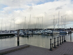
| Photo: The
waterfront at Shore Road, Warsash. |
|
|
|
|
|
 |
|
| Sunday 9 December |
14.26
mi |
22.95
km |
|
|
|
|
| Home to Hamble Square |
8.56
mi |
13.78
km |
|
| Via St Denys Road, Cobden Bridge,
Bullar Road, Bitterne Road, Northam
Bridge, Chapel, Itchen Bridge,
Woolston, Portsmouth Road, Old
Netley, Pound Road and Hamble
Lane. |
|
| Hamble Square to Royal
Victoria Country Park |
4.39
mi |
7.07
km |
|
| To Hamble Quay for refreshments.
Back to Hamble Square then the
rural route via Satchell Lane
to Hamble Lane, Hound Road, Hound
Way, Station Road and Victoria
Road. Into the country park, along
the shore road and round to the
cafe. |
|
| Royal Victoria Country
Park to Hamble Station |
1.31
mi |
2.11
km |
|
| To Hound Road, along the Rail
Trail Paths to Hamble Lane (police
HQ entrance) and Hamble Lane to
Hamble station to catch the train
home. |
|
| A mild day with good sunny spells.
Breezy. |
|
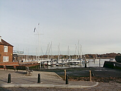
| Photo: Hamble
Quay. |
|
|
|
|
|
 |
|
| Friday 7 December |
12.25
mi |
19.71
km |
|
|
|
|
| Home to Hamble Square |
8.21
mi |
13.21
km |
|
| Via St Denys Road, Cobden Bridge,
Bullar Road, Bitterne Road, Northam
Bridge, Chapel, Itchen Bridge,
Woolston, Weston Shore, Netley,
the Royal Victoria Country Park
and Hamble Lane. |
|
| Hamble Square to Royal
Victoria Country Park |
1.84
mi |
2.96
km |
|
| Down to Hamble Quay for a drink.
Back up to The Square, along Hamble
Lane to the footpath near the
football ground and to the country
park cafe for a longer break. |
|
| Royal Victoria Country
Park to Netley Station |
2.20
mi |
3.54
km |
|
| Out to Hound Road, Hamble Lane,
Hamble station, along the Rail
Trail footpaths to Hound Road,
along the footpath to The Badgers
and Netley station. Train home. |
|
| Damp to begin with, turning
dry with some sunshine. Floods
between Weston Shore and Netley
Abbey. |
|
| Photo: Hamble
Quay. |
|
|
|
|
|
 |
|
| Tuesday 4 December |
13.45
mi |
21.65
km |
|
|
|
|
| Home to Hamble Square |
8.26
mi |
13.29
km |
|
| Via St Denys Road, Cobden Bridge,
Bullar Road, Bitterne Road, Northam
Bridge, Chapel, Itchen Bridge,
Woolston, Weston Shore, Netley,
the Royal Victoria Country Park
and Hamble Lane. |
|
| Hamble Square to Royal
Victoria Country Park |
3.01
mi |
4.84
km |
|
| Down to Hamble Quay for a drink.
Up Green Lane, down School Lane
to Hamble Point and along the
shore to the country park. Round
the country park to the cafe for
a longer break. |
|
| Royal Victoria Country
Park to Netley Station |
2.18
mi |
3.51
km |
|
| Out to Hamble Lane near the
football ground, Hamble station,
along the Rail Trail footpaths
to Hound Road, along the footpath
to The Badgers and Netley station.
Train home. |
|
| Started sunny, turned cloudy.
Mild with a light breeze. |
|
| Photo: Hamble
Quay. |
|
|
|
|
|
| More information and links |
|
|
|
|