|
|
|
 |
|
| Tuesday 31 July |
12.01
mi |
19.33
km |
|
|
|
|
| Home to Hamble Square |
7.80
mi |
12.55
km |
|
| Via St Denys, Horseshoe Bridge,
Itchen Boardwalk, Itchen footpath,
under Northam Bridge, Chapel,
Itchen Bridge, Woolston, Weston
Shore, Netley, Royal Victoria
Country Park and Hamble Lane. |
|
| Hamble Square to Royal
Victoria Country Park |
2.90
mi |
4.67
km |
|
| Down to Hamble Quay for a break
by the river. Up Green Lane and
down School Lane to Hamble Point.
Along the shore to the country
park. Sat by the shore for a while
then across the country park to
the cafe. |
|
| Royal Victoria Country
Park to Hamble Station |
1.31
mi |
2.11
km |
|
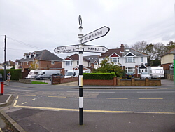
| Hound Road, Hamble Lane, Hamble
station. |
|
| Pleasantly warm with a nice
breeze.. |
|
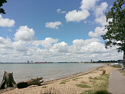
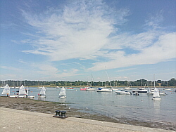
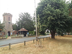
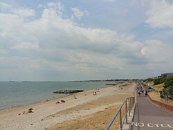
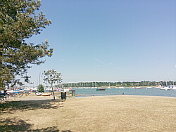
| Photo: Weston
Shore. |
|
|
|
|
|
 |
|
| Friday 27 July |
17.02
mi |
27.39
km |
|
|
|
|
| Home to Warsash Village |
9.67
mi |
15.56
km |
|
| Home to St Denys Road, Horseshoe
Bridge, Itchen Boardwalk and footpath,
under Northam Bridge, Chapel,
Itchen Bridge, Woolston, Portsmouth
Road, Pound Road, Hamble Lane,
Lowford, Lower Swanwick, Sarisbury
Green, Warsash Clock Tower. |
|
| Warsash Village to Warsash
Ferry |
2.19
mi |
3.52
km |
|
| Down Newtown Road and Hook Park
Road, along the Nature Reserve
footpath, to the beach, up the
river footpath, Shore Road and
the footpath to the Hamble ferry.
|
|
| Hamble Quay to Royal Victoria
Country Park |
3.04
mi |
4.89
km |
|
| Up to Hamble Square and down
School Lane to Hamble Point. Along
the shore to the country park
for a break at the cafe. |
|
| Royal Victoria Country
Park to Netley Station |
2.12
mi |
3.41
km |
|
| Out to Hound Road, Hamble Lane,
Hamble station, along the rail
trail footpath and The Badgers
to Netley station for the train
home. |
|
| Started relatively cool but
became humid and thundery. |
|
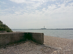
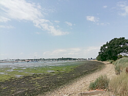
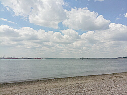
| Photo: The
beach at Warsash looking towards
Calshot. |
|
|
|
|
|
 |
|
| Thursday 26 July |
12.80
mi |
20.60
km |
|
|
|
|
| Home to Hamble Square |
7.82
mi |
12.59
km |
|
| Via St Denys, Horseshoe Bridge,
Itchen Boardwalk, Itchen footpath,
under Northam Bridge, Chapel,
Itchen Bridge, Woolston, Weston
Shore, Netley, Royal Victoria
Country Park and Hamble Lane. |
|
| Hamble Square to Royal
Victoria Country Park |
2.87
mi |
4.62
km |
|
| Down to Hamble Quay for a break
by the river. Up Green Lane and
down School Lane to Hamble Point.
Along the shore to the country
park. Sat by the shore for a while
then across the country park to
the cafe. |
|
| Royal Victoria Country
Park to Netley Station |
2.11
mi |
3.40
km |
|
| Down the Rail Trail footpath
to Hamble station then Hamble
Lane, Hound Road and The Badgers
to Netley station for the train
home. |
|
| Very warm but a nice breeze
at Hamble Quay and at the country
park.. |
|
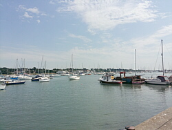
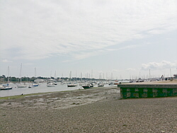
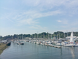
| Photo: Hamble
Quay. |
|
|
|
|
|
 |
|
| Wednesday 25 July |
12.95
mi |
20.84
km |
|
|
|
|
| Home to Hamble Square |
7.80
mi |
12.55
km |
|
| St Denys, Horseshoe Bridge,
Itchen Boardwalk, Itchen footpath,
under Northam Bridge, Chapel,
Itchen Bridge, Woolston, Weston
Shore, Netley, Royal Victoria
Country Park and Hamble Lane. |
|
| Hamble Square to Royal
Victoria Country Park |
3.04
mi |
4.89
km |
|
| Down to Hamble Quay for a break
by the river. Up Green Lane and
round Hamble Common to Hamble
Point. Along to the country park,
a break by the shore then across
the country park to the cafe. |
|
| Royal Victoria Country
Park to Netley Station |
2.11
mi |
3.40
km |
|
| Hound Road, Hamble Lane, Hamble
station, Rail Trail footpath and
The Badgers to Netley station. |
|
| Another very warm day with a
breeze making it pleasant in any
shade. |
|
| Photo: Hamble
Quay. |
|
|
|
|
|
 |
|
| Tuesday 24 July |
15.49
mi |
24.93
km |
|
|
|
|
| Home to Warsash Village |
9.62
mi |
15.48
km |
|
| Home to St Denys Road, Horseshoe
Bridge, Itchen Boardwalk and footpath,
under Northam Bridge, Chapel,
Itchen Bridge, Woolston, Portsmouth
Road, Pound Road, Hamble Lane,
Lowford, Lower Swanwick, Sarisbury
Green, Warsash Clock Tower. |
|
| Warsash Village to Warsash
Ferry |
2.19
mi |
3.52
km |
|
| Down Newtown Road and Hook Park
Road, along the Nature Reserve
footpath, to the beach, up the
river footpath, Shore Road and
the footpath to the Hamble ferry.
|
|
| Hamble Quay to Royal Victoria
Country Park |
2.81
mi |
4.52
km |
|
| Up Green Lane and down School
Lane to Hamble Point. Along the
shore to the country park for
a break by the water then across
the park to the cafe. |
|
| Royal Victoria Country
Park to Hamble Station |
0.87
mi |
1.40
km |
|
| Out to Hound Road and along
the Rail Trail footpath for the
train home. |
|
| Very warm and quite breezy. |
|
| Photo: The
river path from Warsash beach
to Shore Road. |
|
|
|
|
|
 |
|
| Monday 23 July |
16.83
mi |
27.09
km |
|
|
|
|
| Home to Warsash Village |
9.62
mi |
15.48
km |
|
| Home to St Denys Road, Horseshoe
Bridge, Itchen Boardwalk and footpath,
under Northam Bridge, Chapel,
Itchen Bridge, Woolston, Portsmouth
Road, Pound Road, Hamble Lane,
Lowford, Lower Swanwick, Sarisbury
Green, Warsash Clock Tower. |
|
| Warsash Village to Warsash
Ferry |
2.22
mi |
3.57
km |
|
| Down Newtown Road and Hook Park
Road, along the Nature Reserve
footpath, to the beach, up the
river footpath, Shore Road and
the footpath to the Hamble ferry.
|
|
| Hamble Quay to Royal Victoria
Country Park |
2.89
mi |
4.65
km |
|
| Up to Hamble Square and down
School Lane to Hamble Point. Along
the shore to the country park
for a break by the water then
across the park to the cafe. |
|
| Royal Victoria Country
Park to Netley Station |
2.10
mi |
3.38
km |
|
| Out to Hound Road, Hamble Lane,
Hamble station, along the rail
trail footpath and The Badgers
to Netley station for the train
home. |
|
| Very warm with a pleasant breeze
by the water. |
|
| Photo: Warsash
beach. |
|
|
|
|
|
 |
|
| Friday 20 July |
12.85
mi |
20.68
km |
|
|
|
|
| Home to Hamble Square |
7.86
mi |
12.65
km |
|
| St Denys, Horseshoe Bridge,
Itchen Boardwalk, Itchen footpath,
under Northam Bridge, Chapel,
Itchen Bridge, Woolston, Weston
Shore, Netley, Royal Victoria
Country Park and Hamble Lane. |
|
| Hamble Square to Royal
Victoria Country Park |
2.87
mi |
4.62
km |
|
| Down to Hamble Quay for a break
by the river. Up Green Lane and
round Hamble Common to Hamble
Point. Along to the country park,
a break by the shore then across
the country park to the cafe. |
|
| Royal Victoria Country
Park to Netley Station |
2.12
mi |
3.41
km |
|
| Hound Road, Hamble Lane, Hamble
station, Rail Trail footpath and
The Badgers to Netley station. |
|
| Breezy, warm, mostly sunny. |
|
| Photo: Hamble
Quay. |
|
|
|
|
|
 |
|
| Wednesday 18 July |
16.87
mi |
27.15
km |
|
|
|
|
| Home to Warsash Village |
9.60
mi |
15.45
km |
|
| Home to St Denys Road, Horseshoe
Bridge, Itchen Boardwalk and footpath,
under Northam Bridge, Chapel,
Itchen Bridge, Woolston, Portsmouth
Road, Pound Road, Hamble Lane,
Lowford, Lower Swanwick, Sarisbury
Green, Warsash Clock Tower. |
|
| Warsash Village to Warsash
Ferry |
2.20
mi |
3.54
km |
|
| Down Newtown Road and Hook Park
Road, along the Nature Reserve
footpath, to the beach, up the
river footpath, Shore Road and
the footpath to the Hamble ferry.
|
|
| Hamble Quay to Royal Victoria
Country Park |
2.86
mi |
4.60
km |
|
| Up Green Lane and down School
Lane to Hamble Point. Along the
shore to the country park for
a break by the water then across
the park to the cafe. |
|
| Royal Victoria Country
Park to Netley Station |
2.21
mi |
3.56
km |
|
| Out to Hound Road, Hamble Lane,
Hamble station, along the rail
trail footpath to Hound Road then
the footpath, The Badgers and
Netley station. |
|
| Cloudy at times and breezy.
A pleasantly warm day, not too
hot. |
|
| Photo: Sarisbury
Green. |
|
|
|
|
|
 |
|
| Tuesday 17 July |
13.48
mi |
21.69
km |
|
|
|
|
| Home to Hamble Square |
7.87
mi |
12.67
km |
|
| St Denys, Horseshoe Bridge,
Itchen Boardwalk, Itchen footpath,
under Northam Bridge, Chapel,
Itchen Bridge, Woolston, Weston
Shore, Netley, Royal Victoria
Country Park and Hamble Lane. |
|
| Hamble Square to Royal
Victoria Country Park |
3.13
mi |
5.04
km |
|
| Down to Hamble Quay for a break
by the river. Back up to Hamble
Square and down School Lane to
Hamble Point. Along the shore
and across the country park to
the cafe. |
|
| Royal Victoria Country
Park to Netley Station |
2.48
mi |
3.99
km |
|
| Out to Hamble Lane, Hound Road,
Hound Way, Station Road and Netley
station. |
|
| Often cloudy, quite windy, a
much cooler day than recently. |
|
| Photo: Hamble
Quay. |
|
|
|
|
|
 |
|
| Friday 13 July |
12.80
mi |
20.60
km |
|
|
|
|
| Home to Hamble Square |
7.83
mi |
12.60
km |
|
| St Denys, Horseshoe Bridge,
Itchen Boardwalk, Itchen footpath,
under Northam Bridge, Chapel,
Itchen Bridge, Woolston, Weston
Shore, Netley, Royal Victoria
Country Park and Hamble Lane. |
|
| Hamble Square to Royal
Victoria Country Park |
3.88
mi |
6.24
km |
|
| Down to Hamble Quay for a break.
Back up to the Square and along
Hamble Lane. Down Hound Road,
Hound Way and Station Road to
Netley and along Victoria Road
to the shore in the country park. |
|
| Royal Victoria Country
Park to Netley Station |
1.09
mi |
1.75
km |
|
| Across the park to the cafe
for a break. Out to Hound Road,
The Badgers and Netley station. |
|
| A pleasantly warm day with a
couple of heavy showers. |
|
| Photo: Hamble
Quay. |
|
|
|
|
|
 |
|
| Wednesday 11 July |
16.86
mi |
27.13
km |
|
|
|
|
| Home to Warsash Village |
9.56
mi |
15.39
km |
|
| Home to St Denys Road, Horseshoe
Bridge, Itchen Boardwalk and footpath,
under Northam Bridge, Chapel,
Itchen Bridge, Woolston, Portsmouth
Road, Pound Road, Hamble Lane,
Lowford, Lower Swanwick, Sarisbury
Green, Warsash Clock Tower. |
|
| Warsash Village to Warsash
Ferry |
2.24
mi |
3.60
km |
|
| Down Newtown Road and Hook Park
Road, along the Nature Reserve
footpath, to the beach, up the
river footpath, Shore Road and
the footpath to the Hamble ferry.
|
|
| Hamble Quay to Royal Victoria
Country Park |
2.85
mi |
4.59
km |
|
| Up Green Lane and down School
Lane to Hamble Point. Along the
shore to the country park for
a break by the water then across
the park to the cafe. |
|
| Royal Victoria Country
Park to Netley Station |
2.21
mi |
3.56
km |
|
| Out to Hound Road, Hamble Lane,
Hamble station, along the rail
trail footpath to Hound Road then
the footpath, The Badgers and
Netley station. |
|
| Sunny and warm, became cloudy
for a while in the afternoon. |
|
| Photo: The
beach at Warsash. |
|
|
|
|
|
 |
|
| Tuesday 10 July |
13.00
mi |
20.92
km |
|
|
|
|
| Home to Hamble Square |
7.84
mi |
12.62
km |
|
| St Denys, Horseshoe Bridge,
Itchen Boardwalk, Itchen footpath,
under Northam Bridge, Chapel,
Itchen Bridge, Woolston, Weston
Shore, Netley, Royal Victoria
Country Park and Hamble Lane. |
|
| Hamble Square to Royal
Victoria Country Park |
2.93
mi |
4.72
km |
|
| Down to Hamble Quay for a break
by the river. Up Green Lane, down
School Lane to Hamble Point. Along
the shore and, after sitting for
a while by the shore, across the
country park to the cafe. |
|
| Royal Victoria Country
Park to Netley Station |
2.23
mi |
3.59
km |
|
| Out to Hound Road, Hamble Lane,
Hamble station, along the rail
trail footpath to Hound Road then
the footpath, The Badgers and
Netley station. |
|
| A more comfortable temperature
today with a pleasant breeze. |
|
| Photo: Hamble
Quay. |
|
|
|
|
|
 |
|
| Monday 9 July |
15.46
mi |
24.88
km |
|
|
|
|
| Bursledon Station to Titchfield |
4.47
mi |
7.19
km |
|
| To Bridge Road (A27), over the
river and up the hill to Sarisbury
Green and Park Gate. Followed
the old Southampton Road through
the retail park then rejoined
the A27. Down Southampton Hill
to Titchfield village centre and
a short drinks break. |
|
| Titchfield to Meon Shore |
2.69
mi |
4.33
km |
|
| Via Coach Hill, Posbrook Lane,
Triangle Lane and Meon Road. A
good break by the shore. |
|
| Meon Shore to Gosport |
8.30
mi |
13.36
km |
|
| Via Hill Head Harbour to Lee
on the Solent, by road to Stokes
Bay (Browndown Beach closed).
Another break then via Haslar
to Gosport ferry. |
|
| Hot and sunny. Spent the evening
in Ryde. |
|
| Photo: Lee
on the Solent. |
|
|
|
|
|
 |
|
| Friday 6 July |
17.92
mi |
28.84
km |
|
|
|
|
| Home to Warsash Village |
9.55
mi |
15.37
km |
|
| Home to St Denys Road, Horseshoe
Bridge, Itchen Boardwalk and footpath,
under Northam Bridge, Chapel,
Itchen Bridge, Woolston, Portsmouth
Road, Pound Road, Hamble Lane,
Lowford, Lower Swanwick, Sarisbury
Green, Warsash Clock Tower. |
|
| Warsash Village to Warsash
Ferry |
2.22
mi |
3.57
km |
|
| Down Newtown Road and Hook Park
Road, along the Nature Reserve
footpath, to the beach, up the
river footpath to Warsash Shore
(Rising Sun), Shore Road and the
footpath to the Hamble ferry.
|
|
| Hamble Quay to Royal Victoria
Country Park |
2.90
mi |
4.67
km |
|
| Up to Hamble Square and down
School Lane to Hamble Point. Along
the shore to the country park
for a break by the water then
across the park to the cafe. |
|
| Royal Victoria Country
Park to Hamble Station |
3.25
mi |
5.23
km |
|
| To Hamble Lane then Hound Road,
Hound Way and Station Road to
Netley station. The train was
a few minutes late so continued
via The Badgers and the Rail Trail
footpath to Hamble station. |
|
| Hot and mostly sunny. |
|
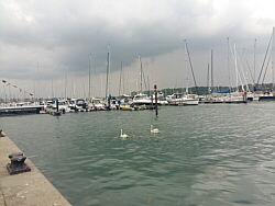
| Photo: The
river Hamble at Bursledon. |
|
|
|
|
|
 |
|
| Thursday 5 July |
13.03
mi |
20.97
km |
|
|
|
|
| Home to Hamble Square |
7.91
mi |
12.73
km |
|
| St Denys, Horseshoe Bridge,
Itchen Boardwalk, Itchen footpath,
under Northam Bridge, Chapel,
Itchen Bridge, Woolston, Weston
Shore, Netley, Royal Victoria
Country Park and Hamble Lane. |
|
| Hamble Square to Royal
Victoria Country Park |
2.91
mi |
4.68
km |
|
| Down to Hamble Quay for a break
by the river. Back up to the Square
and down School Lane to Hamble
Point. Along the shore and, after
sitting for a while by the shore,
across the country park to the
cafe. |
|
| Royal Victoria Country
Park to Netley Station |
2.21
mi |
3.56
km |
|
| Out to Hound Road, Hamble Lane,
Hamble station, along the rail
trail footpath to Hound Road then
the footpath, The Badgers and
Netley station. |
|
| Another very warm day, clouds
built for a while but soon cleared. |
|
| Photo: Hamble
Quay. |
|
|
|
|
|
 |
|
| Wednesday 4 July |
13.14
mi |
21.15
km |
|
|
|
|
| Havant Station to Hayling
Island |
5.56
mi |
8.95
km |
|
| Market Parade, Elm Lane, Park
Road South, Langstone Road, across
the bridge, Hayling Billy Line
Coastal Path, Staunton Avenue,
Sea Front (to Beachlands). |
|
| Beachlands-Eastoke-Beachlands |
1.96
mi |
3.15
km |
|
| Along the beach and seafront
both ways (with a return trip
on the Hayling Railway between). |
|
| Hayling Island to Havant
Station |
5.62
mi |
9.04
km |
|
| From Beachlands: Sea Front,
Staunton Avenue, Hayling Billy
Line Coastal Path, Langstone Bridge,
Langstone Road, Park Road South,
Elm Lane, Market Parade. |
|
| A few clouds but mostly sunny.
A little cooler. |
|
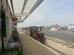
| Photo: The
Hayling Railway at Eastoke. |
|
|
|
|
|
 |
|
| Tuesday 3 July |
12.75
mi |
20.52
km |
|
|
|
|
| Home to Hamble Square |
7.79
mi |
12.54
km |
|
| St Denys, Horseshoe Bridge,
Itchen Boardwalk, Itchen footpath,
under Northam Bridge, Chapel,
Itchen Bridge, Woolston, Weston
Shore, Netley, Royal Victoria
Country Park and Hamble Lane. |
|
| Hamble Square to Royal
Victoria Country Park |
2.85
mi |
4.59
km |
|
| Down to Hamble Quay for a break
by the river. Up Green Lane and
down School Lane to Hamble Point.
Along the shore and across the
country park to the cafe. |
|
| Royal Victoria Country
Park to Netley Station |
2.11
mi |
3.40
km |
|
| Out to Hound Road, Hamble Lane,
Hamble station, along the rail
trail footpath to Hound Road then
across Hound Road to the footpath,
The Badgers and to Netley station. |
|
| Continuing hot and sunny with
a strong breeze along the shore. |
|
| Photo: Hamble
Quay. |
|
|
|
|
|
 |
|
| Monday 2 July |
15.38
mi |
24.75
km |
|
|
|
|
| Home to Warsash Village |
9.49
mi |
15.27
km |
|
| Home to St Denys Road, Horseshoe
Bridge, Itchen Boardwalk and footpath,
under Northam Bridge, Chapel,
Itchen Bridge, Woolston, Portsmouth
Road, Pound Road, Hamble Lane,
Lowford, Lower Swanwick, Sarisbury
Green, Warsash Clock Tower. |
|
| Warsash Village to Warsash
Ferry |
2.20
mi |
3.54
km |
|
| Down Newtown Road and Hook Park
Road, along the Nature Reserve
footpath, to the beach, up the
river footpath to Warsash Shore
(Rising Sun), Shore Road and the
footpath to the Hamble ferry.
|
|
| Hamble Quay to Royal Victoria
Country Park |
2.83
mi |
4.55
km |
|
| Up Green Lane and down School
Lane to Hamble Point. Along the
shore to the country park and
across the park to the cafe. |
|
| Royal Victoria Country
Park to Hamble Station |
0.86
mi |
1.38
km |
|
| Out to Hound Road and down the
Rail Trail footpath to Hamble
station and the train home. |
|
| Hot and sunny. |
|
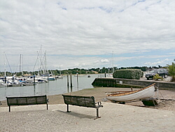
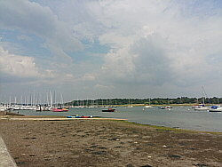
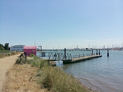
| Photo: The
ferry pontoon at Warsash. |
|
|
|
|
|
| More information and links |
|
|
|
|