|
|
|
|
|
|
| |
Some of the places
I've walked for exercise and leisure
this month. |
|
| |
Places featured
in the Walking Routes pages plus
selected other walks. |
|
|
| |
| |
This August |
13 |
|
walks |
187.83 |
|
miles |
302.28 |
|
km |
|
| |
2017 so far |
80 |
|
walks |
1127.18 |
|
miles |
1814.02 |
|
km |
|
| |
|
|
|
|
|
|
|
|
|
|
|
| |
Last August |
18 |
|
walks |
190.39 |
|
miles |
306.40 |
|
km |
|
| |
To 31/08 last
year |
81 |
|
walks |
889.95 |
|
miles |
1432.24 |
|
km |
|
|
|
| |
| |
|
|
|
|
 |
|
|
|
|
| Tuesday 29 |
11.98
mi |
19.28
km |
|
|
|
|
| Home to Hamble Square |
7.73
mi |
12.44
km |
|
| Via the Itchen Boardwalk and
river path, under Northam Bridge,
through Chapel, over the Itchen
Bridge, through Woolston, along
Weston Shore, through Netley and
the Royal Victoria Country Park
to Hamble Lane and down to Hamble
Square. |
|
| Hamble Square to Royal
Victoria Country Park |
2.98
mi |
4.80
km |
|
| A break at Hamble Quay then
up Green Lane to School Lane and
Hamble Point. Along Hamble Shore
to the Royal Victoria Country
Park cafe for another break. |
|
| Royal Victoria Country
Park to Hamble Station |
1.27
mi |
2.04
km |
|
| Out to Hound Road, Hamble Lane
and Hamble station. |
|
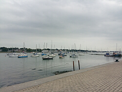
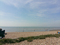
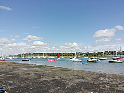
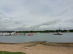
| Photo: The
River Hamble at Hamble Quay, 29.08.17. |
|
|
|
|
|
 |
|
| Monday 28 |
15.08
mi |
24.27
km |
|
|
|
|
| Bursledon Station to Titchfield
|
4.38
mi |
7.05
km |
|
| To the A27 then via Lower Swanwick,
Park Gate, Southampton Road retail
park and Southampton Hill. |
|
| Titchfield to Meon Shore
|
2.68
mi |
4.31
km |
|
| Via Coach Hill, Posbrook Lane,
Triangle Lane and Meon Road. |
|
| Meon Shore to Gosport |
8.02
mi |
12.91
km |
|
| Via Hill Head, Lee on the Solent,
Stokes Bay and Haslar. |
| |
| |
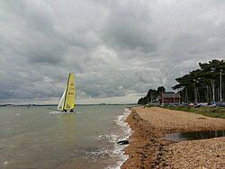
| Photo: Meon
Shore, 28.08.17. |
|
|
|
|
|
|
|
| Sunday 27 |
15.07
mi |
24.25
km |
|
|
|
|
| Home to Warsash Village |
9.48
mi |
15.26
km |
|
| Via the Itchen Boardwalk and
river path, under Northam Bridge,
through Chapel, over the Itchen
Bridge, along Portsmouth Road,
Pound Road and Hamble Lane, through
Lowford, Lower Swanwick and Sarisbury
Green to Warsash Clock Tower.
|
|
| Warsash Village to Warsash
Ferry |
2.18
mi |
3.51
km |
|
| Down Newtown Road and Hook Park
Road, through the nature reserve
to the beach then along the river
path passing Strawberry Field
and the Rising Sun to the Hamble
ferry. |
|
| Hamble Quay to Netley
Station |
3.41
mi |
5.49
km |
|
| Up to Hamble Square, down to
Hamble Point and along the shore.
Through the Royal Victoria Country
Park to Hound Road, The Badgers
and Netley station. |
|
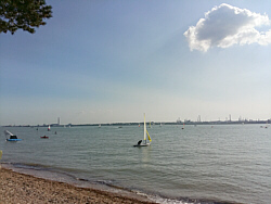
| Photo: Hamble
Shore, Royal Victoria Country
Park, 27.08.17. |
|
|
|
|
|
|
|
| Thursday 24 |
12.60
mi |
20.28
km |
|
|
|
|
| Home to Hamble Square |
7.77
mi |
12.50
km |
|
| Via the Itchen Boardwalk and
river path, under Northam Bridge,
through Chapel, over the Itchen
Bridge, through Woolston, along
Weston Shore, through Netley and
the Royal Victoria Country Park
to Hamble Lane and down to Hamble
Square. |
|
| Hamble Square to Royal
Victoria Country Park |
2.76
mi |
4.44
km |
|
| A break at Hamble Quay then
up Green Lane to School Lane and
Hamble Point. Along Hamble Shore
to the Royal Victoria Country
Park cafe for a break. |
|
| Royal Victoria Country
Park to Netley Station |
2.07
mi |
3.33
km |
|
| Out to Hound Road, Hamble Lane
and Hamble station. From there,
along the rail trail footpath,
across Hound Road and along the
footpath to The Badgers and Netley
station. |
|
| Photo: Hamble
Shore (Netley Sailing Club), 24.08.17. |
|
|
|
|
|
|
|
| Wednesday 23 |
17.05
mi |
27.44
km |
|
|
|
|
| Home to Warsash Village |
9.51
mi |
15.30
km |
|
| Via the Itchen Boardwalk and
river path, under Northam Bridge,
through Chapel, over the Itchen
Bridge, along Portsmouth Road,
Pound Road and Hamble Lane, through
Lowford, Lower Swanwick and Sarisbury
Green to Warsash Clock Tower.
|
|
| Warsash Village to Warsash
Ferry |
2.16
mi |
3.48
km |
|
| Down Newtown Road and Hook Park
Road, through the nature reserve
to the beach and along the river
path passing Strawberry Field
and the Rising Sun to the pink
ferry. |
|
| Hamble Quay to Royal Victoria
Country Park |
2.88
mi |
4.63
km |
|
| Up to Hamble Square, down to
Hamble Point and along the shore.
Finished at the park cafe for
a break. |
|
| Royal Victoria Country
Park to Netley Station |
2.50
mi |
4.02
km |
|
| Out to Hamble Lane via the cemetery
path, turned left to Hound Road
and left again, still Hound Road.
Over the railway bridge and to
Netley station via the footpath
and The Badgers. |
|
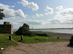
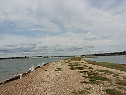
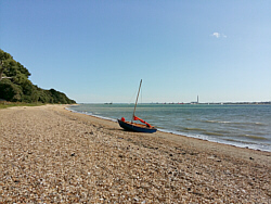
| Photo: Hook
Spit, Warsash beach, 23.08.17. |
|
|
|
|
|
|
|
|
| Saturday 19 |
13.13
mi |
21.13
km |
|
|
|
|
| Home to Lakeside Country
Park |
2.13
mi |
3.43
km |
|
| Via Portswood Road, Swaythling
High Road and Stoneham Lane. |
|
| Lakeside Country Park |
1.03
mi |
1.66
km |
|
| A walk around the park taking
photos of the steam trains. |
|
| Lakeside Country Park
to Hamble Station |
7.50
mi |
12.07
km |
|
| Out to Wide Lane passing the
airport on the way to the A27.
Along the A27 through Mansbridge
to Windhover Roundabout and Hamble
Lane. |
|
| Hamble Station to Netley
Station |
2.47
mi |
3.98
km |
|
| Along Hamble Lane to Coronation
Parade. Then down Coach Road to
the shore and the Royal Victoria
Country Park cafe for a break.
Out of the back of the park to
Hound Road, The Badgers and Netley
station for the train home. |
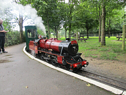
| |
| An improvised day as I wanted
to see the visiting locos at Lakeside,
take some photos on South West
Trains last day of operation and
get a good walk. |
| |
| |
| |
| |
| Photos: |
| Top: One of
the locos visiting Eastleigh Lakeside
Railway from Ingfield Light Railway. |
| Bottom: Hamble
Shore at Westfield Common. |
|
|
|
|
|
|
|
| Wednesday 16 |
11.92
mi |
19.18
km |
|
|
|
|
| Home to Hamble Square |
7.82
mi |
12.59
km |
|
| Via the Itchen Boardwalk and
river path, under Northam Bridge,
through Chapel, over the Itchen
Bridge, through Woolston, along
Weston Shore, through Netley and
the Royal Victoria Country Park
to Hamble Lane and down to Hamble
Square. |
|
| Hamble Square to Hamble
Station |
4.10
mi |
6.60
km |
|
| A break at Hamble Quay then
up Green Lane to School Lane and
down to Hamble Point. Along Hamble
Shore to the Royal Victoria Country
Park cafe for another break. |
|
| From there, out to Hound Road,
Hamble Lane and Hamble station. |
| |
| Photo: The
River Hamble at Hamble Quay, 16.08.17. |
|
|
|
|
|
|
|
| Tuesday 15 |
15.89
mi |
25.57
km |
|
|
|
|
| Home to Warsash Village |
9.52
mi |
15.32
km |
|
| Via the Itchen Boardwalk and
river path, under Northam Bridge,
through Chapel, over the Itchen
Bridge, along Portsmouth Road,
Pound Road and Hamble Lane, through
Lowford, Lower Swanwick and Sarisbury
Green where I had a short drinks
break. |
|
| Warsash Village to Warsash
Ferry |
2.26
mi |
3.64
km |
|
| Down Newtown Road and Hook Park
Road, through the nature reserve
to the beach and along the river
path passing Strawberry Field
and the Rising Sun. A short break
at the beach and another opposite
the Rising Sun. |
|
| Hamble Quay to Royal Victoria
Country Park |
2.88
mi |
4.63
km |
|
| Up to Hamble Square, down to
Hamble Point and along the shore.
Finished at the park cafe for
a break. |
|
| Royal Victoria Country
Park to Hamble Station |
1.23
mi |
1.98
km |
|
| Out to Hamble Lane via the cemetery
path. |
|
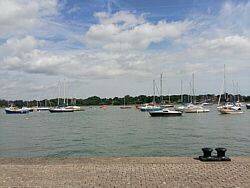
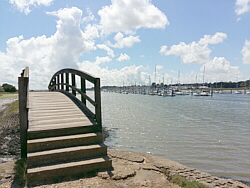
| Photo: Hamble
Shore near the Royal Victoria
Country Park, 15.08.17. |
|
|
|
|
|
|
|
| Friday 11 |
12.97
mi |
20.87
km |
|
|
|
|
| Home to Hamble Square |
7.80
mi |
12.55
km |
|
| Via the Itchen Boardwalk and
river path, under Northam Bridge,
through Chapel, over the Itchen
Bridge, through Woolston, along
Weston Shore, through Netley and
the Royal Victoria Country Park
to Hamble Lane and down to Hamble
Square. |
|
| Hamble Square to Royal
Victoria Country Park |
3.01
mi |
4.84
km |
|
| A break at Hamble Quay then
up Green Lane to School Lane and
Hamble Point. Along Hamble Shore
to the Royal Victoria Country
Park cafe for a break. |
|
| Royal Victoria Country
Park to Netley Station |
2.16
mi |
3.48
km |
|
| Out to Hound Road, Hamble Lane
and Hamble station. From there,
along the rail trail footpath,
across the end of the country
park to Hound Road and along the
footpath to Netley station. |
|
| Photo: The
River Hamble at Hamble Quay, 11.08.17. |
|
|
|
|
|
|
|
| Thursday 10 |
22.45
mi |
36.13
km |
|
|
|
|
| Home to Hamble Quay |
7.86
mi |
12.65
km |
|
| Via the Itchen Boardwalk and
footpath, under Northam Bridge,
through Chapel, over the Itchen
Bridge, through Woolston, along
Weston Shore, through Netley and
the Royal Victoria Country Park
and down Hamble Lane to Hamble
Square and Hamble Quay for the
ferry to Warsash. |
|
| Warsash Shore to Meon
Shore |
5.52
mi |
8.88
km |
|
| The ferry set down at the pontoon
by the harbour office, not at
the normal ferry point. Walked
up to the village, then via Warsash
Road, Common Lane, Posbrook Lane,
Triangle Lane and Meon Road to
Meon Shore (Titchfield Haven). |
|
| Meon Shore to Gosport |
8.09
mi |
13.02
km |
|
| After a short break at Meon
Shore, to Hill Head, Lee on the
Solent, Stokes Bay (for a longer
break), Haslar and Gosport. Ferry
to Portsmouth. |
|
| Portsmouth Harbour to
Portsmouth & Southsea |
0.98
mi |
1.58
km |
|
| From Portsmouth Harbour via
Queen Street, Victoria Park and
the Guildhall to Portsmouth &
Southsea station for the train
home. |
|
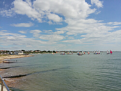
| Photo: Hill
Head (Sailing Club), 10.08.17. |
|
|
|
|
|
|
|
| Monday 7 |
12.62
mi |
20.31
km |
|
|
|
|
| Home to Hamble Square |
7.68
mi |
12.36
km |
|
| Via the Itchen Boardwalk and
river path, under Northam Bridge,
through Chapel, over the Itchen
Bridge, through Woolston, along
Weston Shore, through Netley and
the Royal Victoria Country Park
to Hamble Lane and down to Hamble
Square. |
|
| Hamble Square to Royal
Victoria Country Park |
2.77
mi |
4.46
km |
|
| A break at Hamble Quay then
up Green Lane to School Lane and
Hamble Point. Along Hamble Shore
to the Royal Victoria Country
Park cafe for a break. |
|
| Royal Victoria Country
Park to Netley Station |
2.17
mi |
3.49
km |
|
| Out to Hound Road, Hamble Lane
and Hamble station. From there,
along the rail trail footpath,
across the end of the country
park to Hound Road and along the
footpath to Netley station. |
|
| Photo: Hamble
Quay, 07.08.17. |
|
|
|
|
|
|
|
| Friday 4 |
16.93
mi |
27.25
km |
|
|
|
|
| Home to Warsash Village |
9.53
mi |
15.34
km |
|
| Via the Itchen Boardwalk and
river path, under Northam Bridge,
through Chapel, over the Itchen
Bridge, along Portsmouth Road,
Pound Road and Hamble Lane, through
Lowford, Lower Swanwick and Sarisbury
Green. |
|
| Warsash Village to Warsash
Ferry |
2.21
mi |
3.56
km |
|
| Down Newtown Road and Hook Park
Road, through the nature reserve
to the beach and along the river
path passing Strawberry Field
and the Rising Sun. |
|
| Hamble Quay to Royal Victoria
Country Park |
2.74
mi |
4.41
km |
|
| Up to Hamble Square, down to
Hamble Point and along the shore.
Finished at the park cafe. |
|
| Royal Victoria Country
Park to Netley Station |
2.45
mi |
3.94
km |
|
| Out to Hamble Lane and along
Hound Road and Hound Way. |
|
| Photo: The
river path up-river from Warsash,
04.08.17. |
|
|
|
|
|
|
|
| Tuesday 1 |
10.14
mi |
16.32
km |
|
|
|
|
| Bursledon Station to Warsash
Ferry |
5.44
mi |
8.75
km |
|
| From the station to Bridge Road
and over the river to Swanwick
Shore Road. Along this road, joining
the river path. Down the river,
passing the Universal Marina,
the Hamble ferry and the Rising
Sun pub, all the way to the beach
at the mouth of the river. From
there, through the nature reserve,
up to the village and back to
the ferry. |
|
| Hamble Quay to Hamble
Station |
3.93
mi |
6.32
km |
|
| Up Green Lane and down to Hamble
Point. Along the shore to the
Royal Victoria Country Park for
a break. Out to Hamble Lane and
then Hamble station. |
|
| Hamble Station to Netley
Station |
0.77
mi |
1.24
km |
|
| With a few minutes before the
train was due, down the path alongside
the railway, over Hound Road and
along the footpath to Netley station. |
|
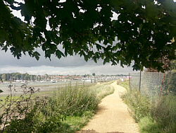
| Photo: The
river Hamble path between Lower
Swanwick and Warsash, 01.08.17 |
|
|
|
|
|
| More information and links |
|
|
|
|
|
|