|
|
|
 |
|
| Tuesday 28 |
15.37
mi |
24.74
km |
|
|
|
|
| Home to Hamble Square |
8.66
mi |
13.94
km |
|
| Via St Denys Road, Cobden Bridge,
Bullar Road, Bitterne Road, Northam
Bridge, Chapel, Itchen Bridge,
Portsmouth Road, Hamble Lane. |
|
| Hamble Square to Royal
Victoria Country Park |
3.86
mi |
6.21
km |
|
| To Hamble Quay for a drinks
break then back to Hamble Square,
Hamble Lane, Hound Road, Hound
Way, Station Road and Netley to
the shore in the Royal Victoria
Country Park. |
|
| Royal Victoria Country
Park |
0.39
mi |
0.63
km |
|
| Across the park to the cafe
for a break. |
|
| Royal Victoria Country
Park to Netley Station |
2.46
mi |
3.96
km |
|
| Out to Hamble Lane, Hound Road,
Hound Way and Netley station for
the train home. |
|
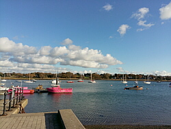
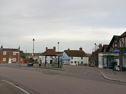
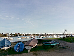
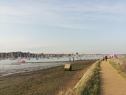
| Photo: Hamble
Quay, 28.11.17. |
|
|
|
|
|
 |
|
| Saturday 25 |
14.46
mi |
23.27
km |
|
|
|
|
| Home to Warsash Village |
10.01
mi |
16.11
km |
|
| Via St Denys Road, Cobden Bridge,
Bullar Road, Bitterne Road, Northam
Bridge, Chapel, Itchen Bridge,
Portsmouth Road, Pound Road, Hamble
Lane, Lowford, Lower Swanwick
and Sarisbury Green. |
|
| Warsash Village to Warsash
Ferry |
0.54
mi |
0.87
km |
|
| Down to the shore in front of
the Rising Sun and along the river
path to the Hamble ferry. |
|
| Hamble Quay to Royal Victoria
Country Park |
2.66
mi |
4.28
km |
|
| Up Green Lane and down School
Lane to Hamble Point. Along Hamble
Shore and across the country park
to the park cafe for a tea break. |
|
| Royal Victoria Country
Park to Netley Station |
1.25
mi |
2.01
km |
|
| Out to Netley village and up
Station Road to Netley station
for the train home. |
|
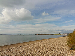
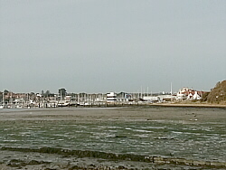
| Photo: The
waterfront at Warsash, 25.11.17. |
|
|
|
|
|
 |
|
| Friday 24 |
11.70
mi |
18.83
km |
|
|
|
|
| Home to Hamble Square |
8.23
mi |
13.24
km |
|
| Via St Denys Road, Cobden Bridge,
Bullar Road, Bitterne Road, Northam
Bridge, Chapel, Itchen Bridge,
Woolston, Weston Shore, Netley,
the Royal Victoria Country Park
and Hamble Lane. |
|
| Hamble Square to Royal
Victoria Country Park |
2.93
mi |
4.72
km |
|
| To Hamble Quay for a drinks
break then back up to Hamble Square,
down School Lane to Hamble Point
and along the shore to the cafe
in the Royal Victoria Country
Park for a cup of tea. |
|
| Royal Victoria Country
Park to Netley Station |
0.54
mi |
0.87
km |
|
| Out to Hound Road and Netley
station via the footpath and The
Badgers. |
|
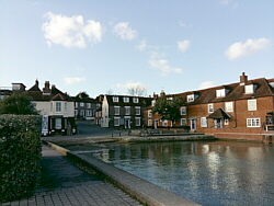
| Photo: Hamble
Square, 24.11.17. |
|
|
|
|
|
 |
|
| Thursday 23 |
13.25
mi |
21.32
km |
|
|
|
|
| Home to Hamble Square |
8.26
mi |
13.29
km |
|
| Via St Denys Road, Cobden Bridge,
Bullar Road, Bitterne Road, Northam
Bridge, Chapel, Itchen Bridge,
Woolston, Weston Shore, Netley,
the Royal Victoria Country Park
and Hamble Lane to Hamble Square.
|
|
| Hamble Square to Royal
Victoria Country Park |
3.83
mi |
6.16
km |
|
| To Hamble Quay for a drinks
break then back to Hamble Square,
Hamble Lane, Hound Road, Hound
Way, Station Road and Netley to
the cafe in the Royal Victoria
Country Park for a longer break. |
|
| Royal Victoria Country
Park to Netley Station |
1.16
mi |
1.87
km |
|
| Out to Hound Road, Hound Way
and Netley station. |
|
| Photo: Hamble
Quay, 23.11.17. |
|
|
|
|
|
 |
|
| Tuesday 21 |
13.68
mi |
22.02
km |
|
|
|
|
| Home to Hamble Square |
8.20
mi |
13.20
km |
|
| St Denys Road, Cobden Bridge,
Bullar Road, Bitterne Road, Northam
Bridge, Chapel, Itchen Bridge
and Woolston, then along Weston
Shore, through Netley and the
Royal Victoria Country Park to
Hamble Lane and Hamble Square.
|
|
| Hamble Square to Royal
Victoria Country Park |
3.86
mi |
6.21
km |
|
| To Hamble Quay for a drinks
break then back to Hamble Square,
Hamble Lane, Hound Road, Hound
Way, Station Road, Netley and
the pier in the Royal Victoria
Country Park. |
|
| Royal Victoria Country
Park to Hamble Station |
1.62
mi |
2.61
km |
|
| Across the park to the cafe
for a tea break. Out to Hound
Road, Hamble Lane and Hamble station. |
|
| Photo: Hamble
Quay, 21.11.17. |
|
|
|
|
|
 |
|
| Sunday 19 |
20.55
mi |
33.07
km |
|
|
|
|
| Home to Titchfield |
11.52
mi |
18.54
km |
|
| Via St Denys Road, Cobden Bridge,
Bullar Road, Bitterne Road, Northam
Bridge, Chapel, Itchen Bridge,
Portsmouth Road, Pound Road, Hamble
Lane, Lowford, Lower Swanwick
and Park Gate. |
|
| Titchfield to Warsash
Ferry |
3.69
mi |
5.94
km |
|
| Via Coach Hill, Common Lane,
Warsash Road and Warsash Village. |
|
| Hamble Quay to Royal Victoria
Country Park |
2.89
mi |
4.65
km |
|
| Up to Hamble Square and down
School Lane to Hamble Point then
long Hamble Shore and across the
country park for a tea break at
the park cafe. |
|
| Royal Victoria Country
Park to Netley Station |
2.45
mi |
3.94
km |
|
| Out to Hamble Lane, Hound Road,
Hound Way and Netley station for
the train home. |
|
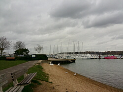
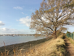
| Photo: The
river Hamble from the ferry at
Warsash. 19.11.17. |
|
|
|
|
|
 |
|
| Friday 17 |
13.45
mi |
21.65
km |
|
|
|
|
| Home to Hamble Square |
8.22
mi |
13.23
km |
|
| Via St Denys Road, Cobden Bridge,
Bullar Road, Bitterne Road, Northam
Bridge, Chapel, Itchen Bridge
and Woolston, along Weston Shore,
through Netley and the Royal Victoria
Country Park to Hamble Lane and
down to Hamble Square. |
|
| Hamble Square to Royal
Victoria Country Park |
3.06
mi |
4.92
km |
|
| To Hamble Quay for a drinks
break then back to Hamble Square
and down School Lane to Hamble
Point. From there, along Hamble
Shore and across the country park
to the park cafe for a tea break. |
|
| Royal Victoria Country
Park to Netley Station |
2.17
mi |
3.49
km |
|
| Out to Hound Road, Hamble Lane
and Hamble station. Found the
train to be slightly delayed,
so ran along the footpaths to
Netley station. |
|
| Photo: Hamble
Quay, 17.11.17. |
|
|
|
|
|
 |
|
| Thursday 16 |
17.55
mi |
28.24
km |
|
|
|
|
| Home to Warsash Village |
10.00
mi |
16.09
km |
|
| Via St Denys Road, Cobden Bridge,
Bullar Road, Bitterne Road, Northam
Bridge, Chapel, Itchen Bridge,
Portsmouth Road, Pound Road, Hamble
Lane, Lowford, Lower Swanwick
and Sarisbury Green to Warsash
Clock Tower. |
|
| Warsash Village to Warsash
Ferry |
2.23
mi |
3.59
km |
|
| Down Newtown Road and Hook Park
Road, through the nature reserve
to the beach for a short break
and a drink. From there along
the river path to the Hamble ferry. |
|
| Hamble Quay to Royal Victoria
Country Park |
2.89
mi |
4.65
km |
|
| Up to Hamble Square and down
School Lane to Hamble Point. Along
Hamble Shore and across the country
park to the park cafe for a tea
break. |
|
| Royal Victoria Country
Park to Netley Station |
2.43
mi |
3.91
km |
|
| Out to Hamble Lane, Hound Road,
Hound Way and Netley station for
the train home. |
|
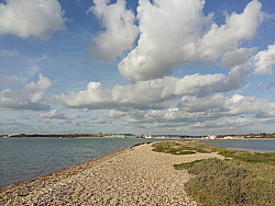
| Photo: The
beach at Warsash, 16.11.17. |
|
|
|
|
|
 |
|
| Wednesday 15 |
13.60
mi |
21.89
km |
|
|
|
|
| Home to Hamble Square |
8.21
mi |
13.21
km |
|
| Via St Denys Road, Cobden Bridge,
Bullar Road, Bitterne Road, Northam
Bridge, Chapel, Itchen Bridge
and Woolston, along Weston Shore,
through Netley and the Royal Victoria
Country Park to Hamble Lane and
down to Hamble Square. |
|
| Hamble Square to Royal
Victoria Country Park |
2.95
mi |
4.75
km |
|
| To Hamble Quay for a drinks
break then up to Green Lane and
School Lane, down to Hamble Point,
along Hamble Shore and across
the country park to the park cafe. |
|
| Royal Victoria Country
Park to Netley Station |
2.44
mi |
3.93
km |
|
| After a break, out to Hamble
Lane, Hound Road, Hound Way and
Netley station for the train home. |
|
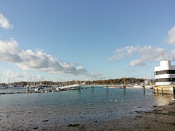
| Photo: Hamble
Quay, 15.11.17. |
|
|
|
|
|
|
|
| Friday 10 |
17.29
mi |
27.83
km |
|
|
|
|
| Home to Warsash Village |
10.01
mi |
16.11
km |
|
| Via St Denys Road, Cobden Bridge,
Bullar Road, Bitterne Road, Northam
Bridge, Chapel, Itchen Bridge,
Portsmouth Road, Pound Road, Hamble
Lane, Lowford, Lower Swanwick
and Sarisbury Green to Warsash
Clock Tower. |
|
| Warsash Village to Warsash
Ferry |
2.19
mi |
3.52
km |
|
| Down Newtown Road and Hook Park
Road, through the nature reserve
to the beach and a drinks break.
From there along the river path
to the Hamble ferry. |
|
| Hamble Quay to Royal Victoria
Country Park |
2.65
mi |
4.26
km |
|
| Up Green Lane and through Hamble
Common to Hamble Point, along
Hamble Shore and across the country
park to the park cafe for a tea
break. |
|
| Royal Victoria Country
Park to Netley Station |
2.44
mi |
3.93
km |
|
| Out to Hamble Lane, along Hound
Road and Hound Way to Netley station. |
|
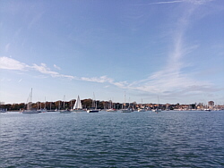
| Photo: The
river Hamble near Warsash Maritime
Academy. 10.11.17. |
|
|
|
|
|
 |
|
| Monday 6 |
17.42
mi |
28.03
km |
|
|
|
|
| Home to Warsash Village |
9.98
mi |
16.06
km |
|
| Via St Denys Road, Cobden Bridge,
Bullar Road, Bitterne Road, Northam
Bridge, Chapel, Itchen Bridge,
Portsmouth Road, Pound Road, Hamble
Lane, Lowford, Lower Swanwick
and Sarisbury Green to Warsash
Clock Tower. |
|
| Warsash Village to Warsash
Ferry |
2.20
mi |
3.54
km |
|
| Down Newtown Road and Hook Park
Road, through the nature reserve
to the beach and a drinks break.
From there along the river path
to the Hamble ferry. |
|
| Hamble Quay to Royal Victoria
Country Park |
2.83
mi |
4.55
km |
|
| Up to Hamble Square, down School
Lane to Hamble Point, along Hamble
Shore and across the country park
to the park cafe for a longer
break. |
|
| Royal Victoria Country
Park to Netley Station |
2.41
mi |
3.88
km |
|
| Out to Hamble Lane, along Hound
Road and Hound Way to Netley station. |
|
| Photo: The
beach at Warsash, 06.11.17. |
|
|
|
|
|
|
|
| Friday 3 |
16.33
mi |
26.28
km |
|
|
|
|
| Home to Warsash Village |
10.00
mi |
16.09
km |
|
| Via St Denys Road, Cobden Bridge,
Bullar Road, Bitterne Road, Northam
Bridge, Chapel, the Itchen Bridge,
Portsmouth Road, Pound Road, Hamble
Lane, Lowford, Lower Swanwick
and Sarisbury Green to Warsash
Clock Tower. |
|
| Warsash Village to Warsash
Ferry |
2.17
mi |
3.49
km |
|
| Down Newtown Road and Hook Park
Road, through the nature reserve
to the beach for a short break.
From there along the river path
to the ferry to Hamble. |
|
| Hamble Quay to Royal Victoria
Country Park |
2.87
mi |
4.62
km |
|
| Up to Hamble Square, down School
Lane to Hamble Point, along Hamble
Shore and across the country park
to the park cafe for a longer
break. |
|
| Royal Victoria Country
Park to Hamble Station |
1.29
mi |
2.08
km |
|
| Out to Hound Road, Hamble Lane
and Hamble station. |
|
| Photo: The
Warsash to Hamble ferry. 03.11.17. |
|
|
|
|
|
|
|
| Wednesday 1 |
17.46
mi |
28.10
km |
|
|
|
|
| Home to Warsash Village |
10.01
mi |
16.11
km |
|
| Via St Denys Road, Cobden Bridge,
Bullar Road, Bitterne Road, Northam
Bridge, Chapel, the Itchen Bridge,
Portsmouth Road, Pound Road, Hamble
Lane, Lowford, Lower Swanwick
and Sarisbury Green to Warsash
Clock Tower. |
|
| Warsash Village to Warsash
Ferry |
2.19
mi |
3.52
km |
|
| Down Newtown Road and Hook Park
Road, through the nature reserve
to the beach and a break. From
there along the river path to
the Hamble ferry. |
|
| Hamble Quay to Royal Victoria
Country Park |
2.83
mi |
4.55
km |
|
| Up to Hamble Square, down School
Lane to Hamble Point, along Hamble
Shore and across the country park
to the park cafe for a break. |
|
| Royal Victoria Country
Park to Netley Station |
2.43
mi |
3.91
km |
|
| Out to Hamble Lane, along Hound
Road and Hound Way to Netley station. |
|
| Photo: Warsash
from the river path. 01.11.17. |
|
|
|
|
|
| More information and links |
|
|
|
|