|
|
|
|
|
|
|
|
|
 |
|
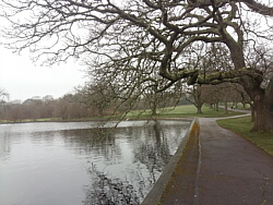
| Tuesday 31 March |
9.21
mi |
14.82
km |
|
|
|
|
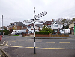
| Airport, Lakeside and
Fleming Park |
|
|
|
| From home to home, via Portswood
Road, Woodmill Lane, Wessex Lane,
, Wide Lane, Lakeside Country
Park, Stoneham Lane, Chestnut
Avenue, Nightingale Avenue, Magpie
Lane, Fleming Park, Passfield
Avenue, Nightingale Avenue, Chestnut
Avenue, Stoneham Lane, High Road
(Swaythling) and Portswood Road. |
|
| An early morning walk and run
before breakfast. |
| |
|
| A chiily breeze but sunny. |
|
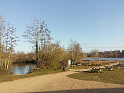
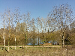
| Photo: Lakeside
Country Park. |
|
|
|
|
|
|
|
|
|
|
|
 |
|
| Friday 27 March |
10.37
mi |
16.69
km |
|
|
|
|
| Riverside Park, Lakeside
and Fleming Park |
|
|
|
| From home to home, via St Denys
Road, Cobden Bridge, Riverside
Park, Mansbridge, A27, Wide Lane,
Lakeside Country Park, Stoneham
Lane, Chestnut Avenue, Nightingale
Avenue, Magpie Lane, Fleming Park,
Passfield Avenue, Nightingale
Avenue, Chestnut Avenue, Stoneham
Lane, High Road (Swaythling) and
Portswood Road. |
|
| An early morning walk and run.
Quite a few people running and
walking in Riverside Park. |
| |
|
| A chiily breeze but the sun
is getting warmer. |
|
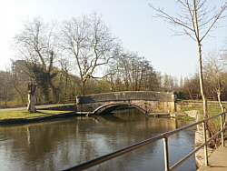
| Photo: The
river Itchen at Mansbridge. |
|
|
|
|
|
|
|
|
|
|
|
 |
|
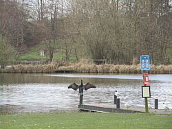
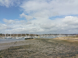
| Wednesday 25 March |
10.45
mi |
16.82
km |
|
|
|
|
| Fleming Park, Lakeside
and Riverside Park |
|
|
|
| From home to home, via Portswood
Road, High Road, Stoneham Lane,
Chestnut Avenue, Nightingale Avenue,
Magpie Lane, Fleming Park, Passfield
Avenue, Nightingale Avenue, Chestnut
Avenue, Stoneham Lane, Lakeside
Country Park, Wide Lane, A27,
Mansbridge, Riverside Park, Cobden
Bridge and St Denys. |
|
| A morning walk and run. Little
traffic and just a few runners
along most of the route. |
| |
|
| Blue sky and feeling like spring
at last. |
|
| Photo: Lakeside
Country Park. |
|
|
|
|
|
|
|
|
|
|
|
 |
|
| Thursday 19 March |
5.82
mi |
9.37
km |
|
|
|
|
|
|
| Needing to make a brief trip
to the city centre I walked in
to town via Bevois Valley and
the city centre parks. |
|
| I returned via The Avenue, Southampton
Common and Highfield. |
| |
|
| Cloudy with some drizzle. |
|
| Photo: The
Boating Lake. |
|
| Personal Covid
Precautions. Travel area, access
to premises and public transport
restricted. |
|
|
|
|
|
|
|
|
|
|
|
 |
|
| Monday 16 March |
19.45
mi |
31.30
km |
|
|
|
|
| Home to Warsash Village |
10.23
mi |
16.46
km |
|
| From home to Cobden Bridge,
Bitterne Park, Bitterne Manor,
Northam Bridge, Northam, Chapel,
Itchen Bridge, Woolston, Portsmouth
Road, Old Netley, Lowford, Lower
Swanwick, Swanwick Shore Road,
Universal Marina, River Hamble
and Warsash village centre. |
|
| Warsash Village to Warsash
Ferry |
0.53
mi |
0.85
km |
|
| Down Shore Road to the waterfront
for a drink break, then along
the footpath to the Hamble ferry
hard. |
|
| Hamble Quay to Royal Victoria
Country Park |
2.81
mi |
4.52
km |
|
| Up to Hamble Square then School
Lane, Hamble Point, Hamble Shore
and the country park. Across the
park to the cafe for a longer
break. |
|
| Royal Victoria Country
Park to Home |
5.88
mi |
9.46
km |
|
| Out to Victoria Road (Netley),
Weston Shore, Woolston, Peartree,
Athelstan Road, Bitterne Park,
Cobden Bridge, St Denys and home. |
|
| A warm, sunny, spring-like day. |
|
| Photo: The
river near the ferry to Hamble. |
|
|
|
|
|
|
|
|
|
|
|
 |
|
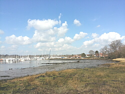
| Saturday 14 March |
6.25
mi |
10.06
km |
|
|
|
|
| Home to Lakeside Country
Park |
3.64
mi |
5.86
km |
|
| From home to Cobden Bridge,
Bitterne Park, Riverside Park,
Mansbridge, Mansbridge Road, Wide
Lane, Lakeside (Doncaster Drove,
railway station). |
|
| Lakeside Country Park
to Home |
2.61
mi |
4.20
km |
|
| Lakeside (railway station, Doncaster
Drove), Stoneham Lane, High Road
(Swaythling), Portswood Road. |
|
| Cloudy, a few spots of rain,
a cold wind. |
|
| Photo: Lakeside
Country Park. |
|
|
|
|
|
|
|
|
|
|
|
 |
|
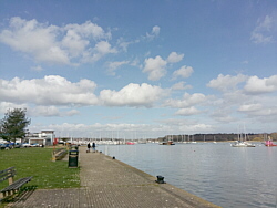
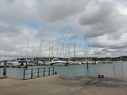
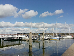
| Friday 13 March |
12.30
mi |
19.79
km |
|
|
|
|
| Home to Hamble Square |
8.59
mi |
13.82
km |
|
| From home to Cobden Bridge,
Bitterne Park, Bitterne Manor,
Northam Bridge, Northam, Chapel,
Itchen Bridge, Woolston, Portsmouth
Road, Old Netley, Hamble Lane,
Satchell Lane and Hamble Square. |
|
| Hamble Square to Royal
Victoria Country Park |
2.50
mi |
4.02
km |
|
| Down to Hamble Quay. A short
break then Green Lane, School
Lane, Hamble Lane, Coach Road,
Westfield Common, Hamble Shore
and the country park. Round the
park for a break outside the cafe. |
|
| Royal Victoria Country
Park to Netley Station |
1.21
mi |
1.95
km |
|
| Out to Hound Road, Hound Way,
Station Road and Netley station
for the train home. |
|
| A few clouds, long sunny spells,
a chilly wind. |
|
| Photo: Hamble
Quay |
|
|
|
|
|
|
|
|
|
|
|
 |
|
| Wednesday 11 March |
13.07
mi |
21.03
km |
|
|
|
|
| Home to Hamble Square |
8.61
mi |
13.86
km |
|
| From home to Cobden Bridge,
Bitterne Park, Bitterne Manor,
Northam Bridge, Northam, Chapel,
Itchen Bridge, Woolston, Portsmouth
Road, Old Netley, Hamble Lane,
Satchell Lane and Hamble Square. |
|
| Hamble Square to Royal
Victoria Country Park |
3.22
mi |
5.18
km |
|
| Down to Hamble Quay then Green
Lane, School Lane, Hamble Lane,
Hound Road (both parts), the Rail
Trail footpath and the Royal Victoria
Country Park cafe. |
|
| Royal Victoria Country
Park to Netley Station |
1.24
mi |
2.00
km |
|
| A break at the cafe then out
to Victoria Road, Station Road
and Netley station for the train
home. |
|
| Mostly cloudy with a blustery
wind. |
|
| Photo: Hamble
Quay |
|
|
|
|
|
|
|
|
|
|
|
 |
|
| Monday 9 March |
13.73
mi |
22.10
km |
|
|
|
|
| Home to Hamble Square |
8.48
mi |
13.65
km |
|
| From home to Cobden Bridge,
Bitterne Park, Bitterne Manor,
Northam Bridge, Northam, Chapel,
Itchen Bridge, Woolston, Portsmouth
Road, Old Netley, Hamble Lane,
Satchell Lane and Hamble Square. |
|
| Hamble Square to Royal
Victoria Country Park |
4.02
mi |
6.47
km |
|
| Down to Hamble Quay then Green
Lane, School Lane, Hamble Lane,
Hound Road, Hound Way, Station
Road, Victoria Road, Royal Victoria
Country Park and round to the
cafe. |
|
| Royal Victoria Country
Park to Netley Station |
1.23
mi |
1.98
km |
|
| A break at the cafe then out
to Hound Road, Hound Way, Station
Road and Netley station for the
train home. |
|
| Started in sunshine but became
cloudy with light rain on the
way home. |
|
| Photo: Hamble
Quay |
|
|
|
|
|
|
|
|
|
|
|
 |
|
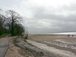
| Saturday 7 March |
12.32
mi |
19.83
km |
|
|
|
|
| Home to Hamble Square |
8.23
mi |
13.24
km |
|
| From home to Cobden Bridge,
Bitterne Park, Bitterne Manor,
Northam Bridge, Northam, Chapel,
Itchen Bridge, Woolston, Weston
Shore, Netley, Royal Victoria
Country Park, Hamble Lane and
Hamble Square. |
|
| Hamble Square to Royal
Victoria Country Park |
2.89
mi |
4.65
km |
|
| Down to Hamble Quay then Green
Lane and School Lane to Hamble
Point. Along the shore to the
country park and across the park
for a break at the cafe. |
|
| Royal Victoria Country
Park to Netley Station |
1.20
mi |
1.93
km |
|
| Out to Hound Road, Hound Way,
Station Road and Netley station
for the train home. |
|
| Cloudy and mild, a chilly wind
later. |
|
| Photo: Weston
Shore |
|
|
|
|
|
|
|
|
|
|
|
 |
|
| Friday 6 March |
14.16
mi |
22.79
km |
|
|
|
|
| Home to Warsash Village |
10.25
mi |
16.50
km |
|
| From home to Cobden Bridge,
Bitterne Park, Bitterne Manor,
Northam Bridge, Northam, Chapel,
Itchen Bridge, Woolston, Portsmouth
Road, Old Netley, Lowford, Lower
Swanwick, Swanwick Shore Road,
Universal Marina, River Hamble
and Warsash village centre. |
|
| Warsash Village to Warsash
Ferry |
0.53
mi |
0.85
km |
|
| Down Shore Road to the waterfront
then along the footpath to the
Hamble ferry hard. |
|
| Hamble Quay to Royal Victoria
Country Park |
2.16
mi |
3.48
km |
|
| Up to Hamble Square then Hamble
Lane, Coach Road, Westfield Common,
Hamble Shore and the country park.
Across the park to the cafe for
a break. |
|
| Royal Victoria Country
Park to Netley Station |
1.22
mi |
1.96
km |
|
| Out to Hound Road, Hound Way,
Station Road and Netley station
for the train home. |
|
| Mostly sunny with a chilly breeze.
A lot of surface water. |
|
| Photo: The
river between Swanwick Shore Road
and Universal Marina. |
|
|
|
|
|
|
|
|
|
|
|
 |
|
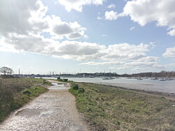
| Tuesday 3 March |
14.75
mi |
23.74
km |
|
|
|
|
| Home to Warsash Village |
10.17
mi |
16.37
km |
|
| From home to Cobden Bridge,
Bitterne Park, Bitterne Manor,
Northam Bridge, Northam, Chapel,
Itchen Bridge, Woolston, Portsmouth
Road, Old Netley, Lowford, Lower
Swanwick, Swanwick Shore Road,
Universal Marina, River Hamble
and Warsash village centre. |
|
| Warsash Village to Warsash
Ferry |
0.54
mi |
0.87
km |
|
| Down Shore Road to the waterfront
then along the footpath to the
Hamble ferry hard. |
|
| Hamble Quay to Royal Victoria
Country Park |
2.81
mi |
4.52
km |
|
| Up to Hamble Square then School
Lane, Hamble Point, Hamble Shore
and the country park. Across the
park to the cafe for a break. |
|
| Royal Victoria Country
Park to Netley Station |
1.23
mi |
1.98
km |
|
| Out to Victoria Road, Station
Road and Netley station for the
train home. |
|
| Cloudy at times but good sunny
spells. A brisk cold wind. |
|
| Photo: The
river between Universal Marina
and Warsash. |
|
|
|
|
|
|
|
|
|
|
|
 |
|
| Monday 2 March |
12.69
mi |
20.42
km |
|
|
|
|
| Home to Hamble Square |
8.57
mi |
13.79
km |
|
| From home to Cobden Bridge,
Bitterne Park, Bitterne Manor,
Northam Bridge, Northam, Chapel,
Itchen Bridge, Woolston, Portsmouth
Road, Old Netley, Hamble Lane,
Satchell Lane and Hamble Square. |
|
| Hamble Square to Royal
Victoria Country Park |
2.90
mi |
4.67
km |
|
| Down to Hamble Quay then Green
Lane and School Lane to Hamble
Point. Along the shore to the
country park and across the park
for a break outside the cafe.
|
|
| Royal Victoria Country
Park to Netley Station |
1.22
mi |
1.96
km |
|
| Out to Victoria Road, Station
Road and Netley station for the
train home. |
|
| Good sunny spells, cold and
windy along Hamble Shore. |
|
| Photo: Hamble
Quay |
|
|
|
|
|
| More information and links |
|
|
|
|