|
|
|
|
|
|
|
|
|
 |
|
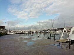
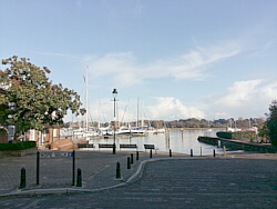
| Saturday 30 November |
15.87
mi |
25.54
km |
|
|
|
|
| Home to Hamble Square |
8.25
mi |
13.28
km |
|
| From home to Bitterne Park,
Bitterne Manor, Northam Bridge,
Northam, Chapel, Itchen Bridge,
Woolston, Weston Shore, Netley
Abbey, Royal Victoria Country
Park, Hamble Lane, Hamble Square. |
|
| Hamble Square to Royal
Victoria Country Park |
2.89
mi |
4.65
km |
|
| Down to Hamble Quay then via
Green Lane and School Lane to
Hamble Point. Along the shore
to the country park and across
the park to the cafe. |
|
| Royal Victoria Country
Park to Royal Victoria Country
Park |
3.54
mi |
5.70
km |
|
| Footpaths to Hamble Lane then
via Hamble Lane, Hound Road, Hound
Way, Station Road and Victoria
Road back to the country park
cafe. |
|
| Royal Victoria Country
Park to Netley Station |
1.19
mi |
1.92
km |
|
| Out to Hound Road, Hound Way,
Station Road and Netley station
for the train home. |
|
| Cloudy with a chilly breeze. |
|
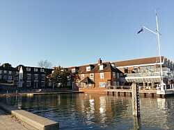
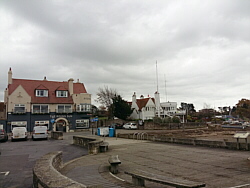
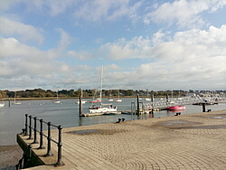
| Photo: Hamble
Shore. |
|
|
|
|
|
|
|
|
|
|
|
 |
|
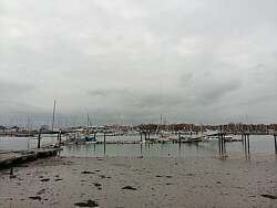
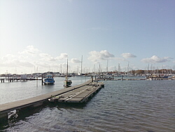
| Friday 29 November |
13.39
mi |
21.55
km |
|
|
|
|
| Home to Hamble Square |
8.24
mi |
13.26
km |
|
| From home to Bitterne Park,
Bitterne Manor, Northam Bridge,
Northam, Chapel, Itchen Bridge,
Woolston, Weston Shore, Netley
Abbey, Royal Victoria Country
Park, Hamble Lane, Hamble Square. |
|
| Hamble Square to Royal
Victoria Country Park |
2.92
mi |
4.70
km |
|
| Down to Hamble Quay for a short
break then Green Lane and School
Lane to Hamble Point. Along the
shore to the country park and
across the park to the cafe for
a drink. |
|
| Royal Victoria Country
Park to Netley Station |
2.23
mi |
3.59
km |
|
| Out to Hound Road, Hamble Lane
and Hamble station. Along the
Rail Trail footpath and through
the orchard to Hound Road then
along the footpath to Netley station
for the train home. |
|
| Sunny with a chilly but light
breeze. |
|
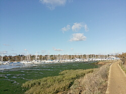
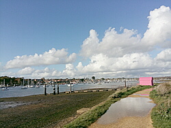
| Photo: Hamble
Quay. |
|
|
|
|
|
|
|
|
|
|
|
 |
|
| Thursday 28 November |
16.04
mi |
25.81
km |
|
|
|
|
| Home to Warsash Village |
10.05
mi |
16.17
km |
|
| From home to Cobden Bridge,
Bitterne Park, Bitterne Manor,
Northam Bridge, Northam, Chapel,
Itchen Bridge, Woolston, Portsmouth
Road, Old Netley, Lowford, Lower
Swanwick, Sarisbury Green and
Warsash village. Stopped to buy
a drink. |
|
| Warsash Village to Warsash
Ferry |
0.52
mi |
0.84
km |
|
| Down Shore Road to the waterfront
for a short break, then along
the footpath to the Hamble ferry
pontoon. |
|
| Hamble Quay to Royal Victoria
Country Park |
2.93
mi |
4.72
km |
|
| Up to Hamble Square then School
Lane to Hamble Point. Along the
shore to the country park. Round
the park for a break and a drink
outside the cafe. |
|
| Royal Victoria Country
Park to Netley Station |
2.54
mi |
4.09
km |
|
| Out to Hamble Lane, Hound Road,
along the footpath to The Badgers
and Netley station for the train
home. |
|
| Sunny with a light breeze, a
bit colder than recent days but
dry. |
|
| Photo: The
ferry shelter, Warsash. |
|
|
|
|
|
|
|
|
|
|
|
 |
|
| Wednesday 27 November |
13.46
mi |
21.66
km |
|
|
|
|
| Home to Hamble Square |
8.28
mi |
13.33
km |
|
| From home to Bitterne Park,
Bitterne Manor, Northam Bridge,
Northam, Chapel, Itchen Bridge,
Woolston, Weston Shore, Netley
Abbey, Royal Victoria Country
Park, Hamble Lane, Hamble Square. |
|
| Hamble Square to Royal
Victoria Country Park |
3.94
mi |
6.34
km |
|
| Down to Hamble Quay for a quick
drink then back up to Hamble Square
and via Hamble Lane, Hound Road,
Hound Way, Station Road and Victoria
Road to the country park cafe. |
|
| Royal Victoria Country
Park to Netley Station |
1.24
mi |
2.00
km |
|
| After a break, out to Hound
Road, Hound Way, Station Road
and Netley station for the train
home. |
|
| Light rain on the way to Hamble,
a little sunshine for a while.
Flooded in places. |
|
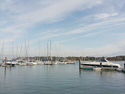
| Photo: Hamble
Quay. |
|
|
|
|
|
|
|
|
|
|
|
 |
|
| Sunday 24 November |
22.75
mi |
36.61
km |
|
|
|
|
| Home to Warsash Village |
10.07
mi |
16.21
km |
|
| From home to Cobden Bridge,
Bitterne Park, Bitterne Manor,
Northam Bridge, Northam, Chapel,
Itchen Bridge, Woolston, Portsmouth
Road, Old Netley, Lowford, Lower
Swanwick, Sarisbury Green and
Warsash village where I bought
a drink. |
|
| Warsash Village to Warsash
Ferry |
0.53
mi |
0.85
km |
|
| Down Shore Road to the waterfront
with the drink, then along the
footpath to the Hamble ferry. |
|
| Hamble Quay to Royal Victoria
Country Park |
3.02
mi |
4.86
km |
|
| Up to Hamble Square then School
Lane to Hamble Point. Along the
shore to the country park. Round
the park for a break and a drink
at the Cafe In The Park. |
|
| Royal Victoria Country
Park to home |
9.13
mi |
14.69
km |
|
| Out to Hamble Lane. Along Hamble
Lane to Tesco (Bursledon) then
the A27 to Mansbridge. Through
Riverside Park to Cobden Bridge,
St Denys Road and home. |
|
| Cloudy and mild with a little
drizzle at times. |
|
| Photo: The
waterfront at Shore Road, Warsash. |
|
|
|
|
|
|
|
|
|
|
|
 |
|
| Thursday 21 November |
13.02
mi |
20.95
km |
|
|
|
|
| Home to Hamble Square |
8.26
mi |
13.29
km |
|
| From home to Bitterne Park,
Bitterne Manor, Northam Bridge,
Northam, Chapel, Itchen Bridge,
Woolston, Weston Shore, Netley
Abbey, Royal Victoria Country
Park, Hamble Lane, Hamble Square. |
|
| Hamble Square to Royal
Victoria Country Park |
3.96
mi |
6.37
km |
|
| Down to Hamble Quay. A quick
drink then back up to Hamble Square
and via Hamble Lane, Hound Road,
Hound Way, Station Road and Victoria
Road to the country park shore
(site of the old pier). |
|
| Royal Victoria Country
Park to Netley Station |
0.80
mi |
1.29
km |
|
| Across the park for a break
outside the Cafe in the Park.
Out to Hound Road then along the
footpath to The Badgers and Netley
station for the train home. |
|
| Heavy cloud and a cold, gusty
wind. |
|
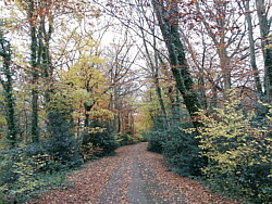
| Photo: The
country park path to the cemetery
and Hamble. |
|
|
|
|
|
|
|
|
|
|
|
 |
|
| Wednesday 20 November |
12.49
mi |
20.10
km |
|
|
|
|
| Home to Hamble Square |
8.25
mi |
13.28
km |
|
| From home to Bitterne Park,
Bitterne Manor, Northam Bridge,
Northam, Chapel, Itchen Bridge,
Woolston, Weston Shore, Netley
Abbey, Royal Victoria Country
Park, Hamble Lane, Hamble Square. |
|
| Hamble Square to Royal
Victoria Country Park |
3.02
mi |
4.86
km |
|
| Down to Hamble Quay. A quick
drink then via Hamble Square and
School Lane to Hamble Point. Along
the shore to the country park.
Across the park to the cafe. |
|
| Royal Victoria Country
Park to Netley Station |
1.22
mi |
1.96
km |
|
| Out to Hound Road, Hound Way,
Station Road and Netley station
for the train home. |
|
| Quite cloudy, a strong cold
wind. |
|
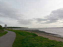
| Photo: Weston
Shore. |
|
|
|
|
|
|
|
|
|
|
|
 |
|
| Tuesday 19 November |
14.78
mi |
23.79
km |
|
|
|
|
| Home to Warsash Village |
10.02
mi |
16.13
km |
|
| From home to Cobden Bridge,
Bitterne Park, Bitterne Manor,
Northam Bridge, Northam, Chapel,
Itchen Bridge, Woolston, Portsmouth
Road, Old Netley, Lowford, Lower
Swanwick, Sarisbury Green and
Warsash village. Paused to buy
a drink. |
|
| Warsash Village to Warsash
Ferry |
0.55
mi |
0.89
km |
|
| Down Shore Road to the waterfront
for a quick drink, then along
the footpath to the Hamble ferry. |
|
| Hamble Quay to Royal Victoria
Country Park |
2.92
mi |
4.70
km |
|
| Up to Hamble Square then School
Lane to Hamble Point. Along the
shore to the country park. Round
the park for a break and a drink
outside the cafe. |
|
| Royal Victoria Country
Park to Netley Station |
1.29
mi |
2.08
km |
|
| Out to Victoria Road (Netley
village), Station Road and Netley
station. |
|
| Cloudy with a few spots of rain,
some sun later in the afternoon. |
|
| Photo: Shore
Road, Warsash. |
|
|
|
|
|
|
|
|
|
|
|
 |
|
| Monday 18 November |
15.95
mi |
25.67
km |
|
|
|
|
| Home to Warsash Village |
10.29
mi |
16.56
km |
|
| From home to Bitterne Park,
Bitterne Manor, Northam Bridge,
Northam, Chapel, Itchen Bridge,
Woolston, Portsmouth Road, Old
Netley, Lowford, Lower Swanwick,
Swanwick Shore Road, Universal
Marina, River Hamble Path, Passage
Lane and Warsash village. |
|
| Warsash Village to Warsash
Ferry |
0.53
mi |
0.85
km |
|
| Down Shore Road to the waterfront
for a quick drink, then to the
ferry pontoon. |
|
| Hamble Quay to Royal Victoria
Country Park |
2.92
mi |
4.70
km |
|
| Up to Hamble Square then School
Lane to Hamble Point. Along the
shore to the country park. Round
the park for a break and a drink
in the sunshine outside the cafe.
|
|
| Royal Victoria Country
Park to Netley Station |
2.21
mi |
3.56
km |
|
| Out to Hound Road, Hamble Lane
and Hamble station. Along the
Rail Trail footpath and through
the orchard to Hound Road then
along the footpath to Netley station. |
|
| Sunny with an almost clear sky
and a light breeze. |
|
| Photo: The
river Hamble. |
|
|
|
|
|
|
|
|
|
|
|
 |
|
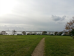
| Sunday 17 November |
16.61
mi |
26.73
km |
|
|
|
|
| Home to Hamble Square |
7.58
mi |
12.20
km |
|
| From home to Cobden Bridge,
Bitterne Park, Peartree, Woolston,
Portsmouth Road, Old Netley, Hamble
Lane, Hamble Square. |
|
| Hamble Square to Royal
Victoria Country Park |
2.84
mi |
4.57
km |
|
| Down to Hamble Quay then via
Green Lane and School Lane to
Hamble Point. Along the shore
to the country park. Across the
park to the cafe for a drink. |
|
| Royal Victoria Country
Park to home |
6.19
mi |
9.96
km |
|
| Out to Victoria Road, Netley
Abbey, Weston Shore, Woolston,
Itchen Bridge, Chapel, Northam,
under Northam Bridge, along the
river Itchen footpath and boardwalk,
then St Denys and home. |
|
| Very pleasant in sunshine with
a light breeze. |
|
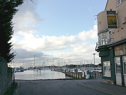
| Photo: Hamble
Quay. |
|
|
|
|
|
|
|
|
|
|
|
 |
|
| Saturday 16 November |
18.81
mi |
30.27
km |
|
|
|
|
| Home to Warsash Village |
9.12
mi |
14.68
km |
|
| From home to Cobden Bridge,
Bitterne Park, Bitterne Station,
Athelstan Road, Peartree, Woolston
station, Portsmouth Road, Old
Netley, Lowford, Lower Swanwick,
Sarisbury Green and Warsash village. |
|
| Warsash Village to Warsash
Ferry |
0.53
mi |
0.85
km |
|
| Bought a drink and walked down
Shore Road to the waterfront and
then the ferry pontoon. |
|
| Hamble Quay to Royal Victoria
Country Park |
2.91
mi |
4.68
km |
|
| Up to Hamble Square then School
Lane to Hamble Point. Along the
shore to the country park. Round
the park for a break and a drink
outside the cafe. |
|
| Royal Victoria Country
Park to home |
6.25
mi |
10.06
km |
|
| Out to Victoria Road, Netley
Abbey, Weston Shore, Woolston,
Itchen Bridge, Chapel, Northam,
under Northam Bridge, along the
river Itchen footpath and boardwalk,
then St Denys and home. |
|
| Sunny for much of the time,
cloudy later. |
|
| Photo: Shore
Road, Warsash. |
|
|
|
|
|
|
|
|
|
|
|
 |
|
| Thursday 14 November |
13.25
mi |
21.32
km |
|
|
|
|
| Home to Hamble Square |
8.27
mi |
13.31
km |
|
| From home to Bitterne Park,
Bitterne Manor, Northam Bridge,
Northam, Chapel, Itchen Bridge,
Woolston, Weston Shore, Netley
Abbey, Royal Victoria Country
Park, Hamble Lane, Hamble Square. |
|
| Hamble Square to Royal
Victoria Country Park |
2.89
mi |
4.65
km |
|
| Down to Hamble Quay then via
Green Lane and School Lane to
Hamble Point. Along the shore
to the country park. Across the
park to the cafe for a drink. |
|
| Royal Victoria Country
Park to Netley Station |
2.09
mi |
3.36
km |
|
| Out to Hound Road, the Rail
Trail footpath, Hamble station
and Hound Road, back towards the
country park then along the footpath
to The Badgers and Netley station. |
|
| Cold and grey until Hamble then
good spells of sunshine. |
|
| Photo: Hamble
Quay. |
|
|
|
|
|
|
|
|
|
|
|
 |
|
| Wednesday 13 November |
16.10
mi |
25.91
km |
|
|
|
|
| Home to Warsash Village |
10.04
mi |
16.16
km |
|
| From home to Bitterne Park,
Bitterne Manor, Northam Bridge,
Northam, Chapel, Itchen Bridge,
Woolston, Portsmouth Road, Old
Netley, Lowford, Lower Swanwick,
Sarisbury Green and Warsash village. |
|
| Warsash Village to Warsash
Ferry |
0.70
mi |
1.13
km |
|
| Bought a drink and walked down
Newtown Road, across Strawberry
Field then along the footpath
to Shore Road, the waterfront
and the ferry pontoon. |
|
| Hamble Quay to Royal Victoria
Country Park |
2.87
mi |
4.62
km |
|
| Up Green Lane then School Lane
to Hamble Point. Along the shore
to the country park. Round the
park to the for a break and a
drink outside the cafe. |
|
| Royal Victoria Country
Park to Netley Station |
2.49
mi |
4.01
km |
|
| Out to Hamble Lane, Hound Road,
Hound Way, Station Road and Netley
station for the train home. |
|
| Long sunny spells, cloudy at
times, a lighter wind than recent
days. |
|
| Photo: Warsash
- Strawberry Field, the river
Hamble and Southampton Water. |
|
|
|
|
|
|
|
|
|
|
|
 |
|
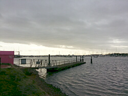
| Tuesday 12 November |
12.84
mi |
20.66
km |
|
|
|
|
| Home to Warsash Village |
10.04
mi |
16.16
km |
|
| From home to Bitterne Park,
Bitterne Manor, Northam Bridge,
Northam, Chapel, Itchen Bridge,
Woolston, Portsmouth Road, Old
Netley, Lowford, Lower Swanwick,
Sarisbury Green and Warsash village. |
|
| Warsash Village to Warsash
Ferry |
0.53
mi |
0.85
km |
|
| Down Shore Road to the waterfront
for a quick drink, then to the
ferry pontoon. |
|
| Hamble Quay to Royal Victoria
Country Park |
1.70
mi |
2.74
km |
|
| Up to Hamble Square, along Hamble
Lane to the football ground and
the footpath to the country park.
Across the park to the cafe for
a break and a drink. |
|
| Royal Victoria Country
Park to Netley Station |
0.57
mi |
0.92
km |
|
| The direct route to Hound Road,
along the footpath to The Badgers
and Netley station for the train
home. |
|
| Sunny until Warsash then heavy
cloud and light rain. A cold wind. |
|
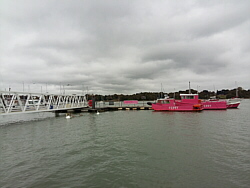
| Photo: The
river Hamble at Warsash ferry
pontoon. |
|
|
|
|
|
|
|
|
|
|
|
 |
|
| Monday 11 November |
15.95
mi |
25.67
km |
|
|
|
|
| Home to Warsash Village |
10.07
mi |
16.21
km |
|
| From home to Bitterne Park,
Bitterne Manor, Northam Bridge,
Northam, Chapel, Itchen Bridge,
Woolston, Portsmouth Road, Old
Netley, Lowford, Lower Swanwick,
Sarisbury Green and Warsash village. |
|
| Warsash Village to Warsash
Ferry |
0.52
mi |
0.84
km |
|
| Down Shore Road to the waterfront
for a quick drink, then to the
ferry pontoon. |
|
| Hamble Quay to Royal Victoria
Country Park |
2.84
mi |
4.57
km |
|
| Up Green Lane then School Lane
to Hamble Point. Along the shore
to the country park. Round the
park to the cafe for a break and
a drink. |
|
| Royal Victoria Country
Park to Netley Station |
2.52
mi |
4.06
km |
|
| Out to Hamble Lane, Hound Road,
along the footpath to The Badgers
and Netley station for the train
home. |
|
| Good sunny spells, cloudy at
times, a cold wind. |
|
| Photo: The
river Hamble at Warsash waterfront,
Shore Road. |
|
|
|
|
|
|
|
|
|
|
|
 |
|
| Friday 8 November |
12.31
mi |
19.81
km |
|
|
|
|
| Home to Hamble Square |
8.29
mi |
13.34
km |
|
| From home to Bitterne Park,
Bitterne Manor, Northam Bridge,
Northam, Chapel, Itchen Bridge,
Woolston, Weston Shore, Netley
Abbey, Royal Victoria Country
Park, Hamble Lane, Hamble Square. |
|
| Hamble Square to Royal
Victoria Country Park |
2.78
mi |
4.47
km |
|
| Down to Hamble Quay. A quick
drink then via Green Lane and
School Lane to Hamble Point. Along
the shore to the country park.
Across the park to the cafe. |
|
| Royal Victoria Country
Park to Netley Station |
1.24
mi |
2.00
km |
|
| Out to Hound Road, Hound Way,
Station Road and Netley station
for the train home. |
|
| A lot of cloud, some sunny breaks. |
|
| Photo: Hamble
Quay. |
|
|
|
|
|
|
|
|
|
|
|
 |
|
| Thursday 7 November |
15.23
mi |
24.51
km |
|
|
|
|
| Home to Warsash Village |
10.30
mi |
16.58
km |
|
| From home to Bitterne Park,
Bitterne Manor, Northam Bridge,
Northam, Chapel, Itchen Bridge,
Woolston, Portsmouth Road, Old
Netley, Lowford, Lower Swanwick,
Swanwick Shore Road, Universal
Marina, River Hamble Path, Passage
Lane and Warsash village. |
|
| Warsash Village to Warsash
Ferry |
0.55
mi |
0.89
km |
|
| Down Shore Road to the waterfront
for a quick drink, then to the
ferry hard. |
|
| Hamble Quay to Royal Victoria
Country Park |
2.18
mi |
3.51
km |
|
| Up to Hamble Square then Hamble
Lane and Coach Road to Westfield
Common. Along the shore to the
country park. Round the park to
the cafe to relax outside with
a drink. |
|
| Royal Victoria Country
Park to Netley Station |
2.20
mi |
3.54
km |
|
| Out to Hound Road, Hamble Lane
and Hamble station. Along the
Rail Trail footpath and through
the orchard to Hound Road then
along the footpath to Netley station. |
|
| Good sunny spells, cloudy at
times but the rain passed by. |
|
| Photo: The
river Hamble and Warsash ferry
pontoon. |
|
|
|
|
|
|
|
|
|
|
|
 |
|
| Friday 1 November |
14.10
mi |
22.69
km |
|
|
|
|
| Home to Hamble Square |
8.27
mi |
13.31
km |
|
| From home to Bitterne Park,
Bitterne Manor, Northam Bridge,
Northam, Chapel, Itchen Bridge,
Woolston, Weston Shore, Netley
Abbey, Royal Victoria Country
Park, Hamble Lane, Hamble Square. |
|
| Hamble Square to Royal
Victoria Country Park |
3.28
mi |
5.28
km |
|
| Down to Hamble Quay. A break
for a snack and a drink then via
Green Lane and School Lane to
Hamble Point. Along the shore
and paths to the country park.
Round the park to the cafe for
another break. |
|
| Royal Victoria Country
Park to Netley Station |
2.55
mi |
4.10
km |
|
| Out to Hamble Lane, Hamble station
and Hound Road, back towards the
country park then along the footpath
to The Badgers and Netley station. |
|
| Mild, cloudy and misty, some
drizzle. |
|
| Photo: Hamble
Quay. |
|
|
|
|
|
| More information and links |
|
|
|
|