|
|
|
|
|
| Friday 30 |
7.58
mi |
12.20
km |
|
|
|
|
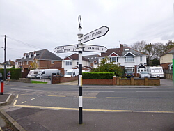
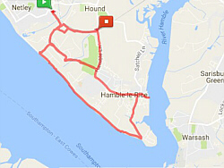
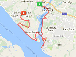
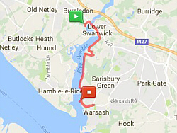
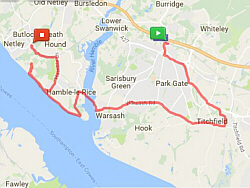
| Netley Station to Hamble
Station |
7.58
mi |
12.20
km |
|
| From Netley station, through
the Royal Victoria Country Park
to Hamble, down to Hamble Point,
along the shore, back through
the country park and round to
Hamble station. |
|
|
|
| |
|
|
|
| |
| |
| |
|
|
|
|
|
 |
|
| Thursday 29 |
14.34
mi |
23.08
km |
|
|
|
|
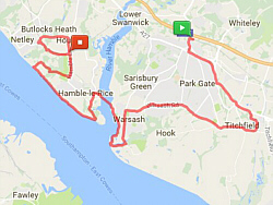
| Swanwick Station to Warsash |
6.07
mi |
9.77
km |
|
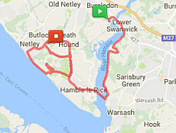
| Swanwick station to Warsash
beach via Park Gate, Segensworth,
Titchfield and Warsash Village. |
|
| Warsash Clock Tower to
Hook Shore |
1.14
mi |
1.83
km |
|
| Warsash village, Newtown Road,
Hook Park Road, Nature Reserve
Path, Warsash beach. |
|
| Hook Shore to Royal Victoria
Country Park |
3.93
mi |
6.33
km |
|
| From the beach to the ferry,
over to Hamble and along the shore
to the Royal Victoria Country
Park. |
|
| Royal Victoria Country
Park to Hamble Station |
3.20
mi |
5.15
km |
|
| Then out to Hamble Lane, along
Hamble Road and Hamble Way, passing
Netley station to Hamble station. |
| |
| |
|
|
|
|
|
|
|
| Wednesday 28 |
15.17
mi |
24.41
km |
|
|
|
|
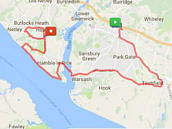
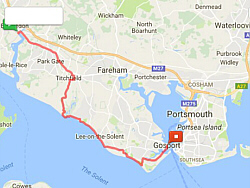
| Bursledon Station to Titchfield |
4.43
mi |
7.13
km |
|
| Bursledon station, Park Gate,
Segensworth, Titchfield. |
|
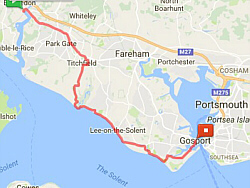
| Titchfield to Meon Shore |
2.68
mi |
4.31
km |
|
| Titchfield, Coach Hill, Posbrook
Lane, Triangle Lane, Meon Road,
Meon Shore. |
|
| Meon Shore to Gosport |
8.06
mi |
12.97
km |
|
| Meon Shore, Hill Head, Lee on
the Solent, Stokes Bay, Haslar,
Gosport ferry. |
| |
| |
|
|
|
|
|

|
|
| Friday 23 |
13.65
mi |
21.97
km |
|
|
|
|
| Swanwick Station to Warsash
(Hook Shore) |
7.17
mi |
11.54
km |
|
| Swanwick station, Park Gate,
Segensworth, Titchfield, Warsash
village, Newtown Road, Hook Park
Road, Nature Reserve Path, Warsash
beach. |
|
| Warsash Beach to Royal
Victoria Country Park |
4.01
mi |
6.45
km |
|
| Warsash beach, Hamble ferry
via river path. Hamble Quay, Hamble
Square, Hamble Shore, Royal Victoria
Country Park. |
|
| Royal Victoria Country
Park to Netley Station |
2.47
mi |
3.98
km |
|
| Royal Victoria Country Park,
Hamble Lane, Hound Road, Hound
Way, Netley station. |
| |
| |
|
|
|
|
|
|
|
| Thursday 22 |
10.48
mi |
16.87
km |
|
|
|
|
| Bursledon Station to Warsash
Ferry |
5.52
mi |
8.88
km |
|
| Bursledon station, Lower Swanwick,
Swanwick Shore Road, river path
to the beach at the mouth of the
Hamble, river path and Strawberry
Field to Warsash village, Warsash
Ferry. |
|
| Hamble Quay to Netley
Station |
4.96
mi |
7.98
km |
|
| Hamble Quay, Hamble Square,
Hamble Point, Hamble Shore, Royal
Victoria Country Park, Hamble
Lane, Hamble station, rail-trail
path and The Badgers to Netley
station. |
|
|
|
| |
| |
| |
|
|
|
|
|
 |
|
| Wednesday 21 |
15.75
mi |
25.35
km |
|
|
|
|
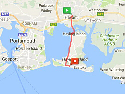
| Havant Station to Hayling
(Beachlands) |
5.69
mi |
9.16
km |
|
| Havant station, Langstone bridge,
Hayling railway path, Beachlands. |
|
| Beachlands to Beachlands |
4.43
mi |
7.13
km |
|
| Beachlands, Eastoke Corner,
Sandy Point, Eastoke Corner, Beachlands. |
|
| Beachlands to Havant Station |
5.63
mi |
9.06
km |
|
| Beachlands, Hayling railway
path, Langstone bridge, Havant
station. |
| |
| |
|
|
|
|
|
|
|
| Thursday 15 |
12.67
mi |
20.39
km |
|
|
|
|
| Swanwick Station to Warsash
Clock Tower |
6.03
mi |
9.70
km |
|
| Swanwick Station, Park Gate,
Segensworth, Titchfield, Warsash
Village. |
|
| Warsash Clock Tower to
shore at Rising Sun then
ferry |
3.44
mi |
5.54
km |
| and Hamble Quay to Royal
Victoria Country Park |
|
|
|
| Warsash Village, Shore Road
and Ferry. Hamble Quay, Hamble
Square, Hamble Point, Hamble Shore,
Royal Victoria Country Park. |
|
| Royal Victoria Country
Park to Hamble Station |
3.20
mi |
5.15
km |
|
| Royal Victoria Country Park,
Hamble Lane, Hound Road, Hound
Way, Netley Station, The Badgers,
Footpaths, Hamble Station. |
| |
| |
|
|
|
|
|
|
|
| Wednesday 14 |
15.12
mi |
24.33
km |
|
|
|
|
| Bursledon Station to Titchfield |
4.40
mi |
7.08
km |
|
| Bursledon Station, Park Gate,
Segensworth, Titchfield. |
|
| Titchfield to Meon Shore |
2.68
mi |
4.31
km |
|
| Titchfield, Coach Hill, Posbrook
Lane, Triangle Lane, Meon Road,
Meon Shore. |
|
| Meon Shore to Gosport |
8.04
mi |
12.94
km |
|
| Meon Shore, Hill Head, Lee on
the Solent, Stokes Bay, Haslar,
Gosport ferry. |
| |
| |
|
|
|
|
|
|
|
| Tuesday 13 |
7.75
mi |
12.47
km |
|
|
|
|
| Bursledon Station to Warsash |
3.97
mi |
6.39
km |
|
| Bursledon Station, Swanwick
Shore Road, Causeway, Warsash
Village, back to the ferry. |
|
| Hamble Quay to Hamble
Station |
3.78
mi |
6.08
km |
|
| Hamble Quay, Hamble Square,
Hamble Point, Hamble Shore, Royal
Victoria Country Park, Hamble
Station. |
|
|
|
| |
| |
| |
|
|
|
|
|
|
|
| Friday 9 |
9.28
mi |
14.93
km |
|
|
|
|
| Bursledon Station to Warsash
(Ferry) |
2.98
mi |
4.80
km |
|
| Bursledon Station, Swanwick
Shore Road, Causeway, Warsash
Ferry. |
|
| Hamble Quay to Royal Victoria
Country Park |
4.23
mi |
6.81
km |
|
| Hamble Quay, Hamble Square,
Hamble Lane, Hound Road, Netley
Village, Royal Victoria Country
Park. |
|
| Royal Victoria Country
Park to Netley Station |
2.07
mi |
3.33
km |
|
| Royal Victoria Country Park,
Hamble Lane, Hamble Station, Footpath,
The Badgers, Netley Station. |
| |
| |
|
|
|
|
|
|
|
| Thursday 8 |
15.24
mi |
24.53
km |
|
|
|
|
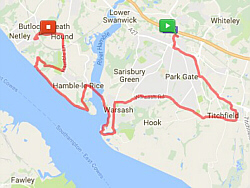
| Bursledon Station to Titchfield |
4.42
mi |
7.11
km |
|
| Bursledon station, Park Gate,
Segensworth, Titchfield. |
|
| Titchfield to Meon Shore |
2.70
mi |
4.35
km |
|
| Titchfield, Coach Hill, Posbrook
Lane, Triangle Lane, Meon Road,
Meon Shore. |
|
| Meon Shore to Gosport |
8.12
mi |
13.07
km |
|
| Meon Shore, Hill Head, Lee on
the Solent, Stokes Bay, Haslar,
Gosport ferry. Breaks taken at
Titchfield, Meon Shore and Stokes
Bay. |
| |
| |
|
|
|
|
|
|
|
| Wednesday 7 |
13.47
mi |
21.68
km |
|
|
|
|
| Swanwick Station to Titchfield |
2.77
mi |
4.46
km |
|
| Swanwick station to Park Gate,
Segensworth and Titchfield. |
|
| Titchfield to Warsash
Village |
3.26
mi |
5.25
km |
|
| Titchfield to Warsash village |
|
| Warsash Village to Southampton
Water |
1.16
mi |
1.87
km |
|
| From Warsash village via Newtown
Road, Hook Park Road and the nature
reserve footpath to the beach
at Southampton Water. |
|
| Southampton Water to the
Hamble Ferry |
1.06
mi |
1.71
km |
|
| Back along the river and over
to Hamble. |
|
| Hamble to Netley Station
|
5.22
mi |
8.40
km |
|
| From Hamble Quay to Hamble Point,
along the shore to the Royal Victoria
Country Park, out along Hamble
Lane and round to Netley station. |
| |
|
|
|
|
|

|
|
| Friday 2 |
9.01
mi |
14.50
km |
|
|
|
|
| Hamble Station to Royal
Victoria Country Park |
4.28
mi |
6.89
km |
|
| Hamble station, Hamble Lane,
Hamble Square, Hamble Quay, Hamble
Square, School Lane, Hamble Point,
Hamble Shore, Royal Victoria Country
Park. |
|
| Royal Victoria Country
Park to Hamble Point |
2.15
mi |
3.46
km |
|
| Royal Victoria Country Park,
Hamble Shore, Hamble Point. |
|
| Hamble Point to Netley
Station |
2.58
mi |
4.15
km |
|
| Hamble Point, School Lane, Copse
Lane, Hamble Lane, Hamble station,
Rail-Trail footpath, The Badgers,
Netley station. |
| |
| |
|
|
|
|
|
|
|
| Thursday 1 |
12.00
mi |
13.04
km |
|
|
|
|
| Swanwick Station to Warsash
Clock Tower |
6.02
mi |
9.69
km |
|
| Swanwick station to Park Gate,
Segensworth, Titchfield and Warash
village. |
|
| Warsash Clock Tower to
Ferry |
0.50
mi |
0.80
km |
|
| Down to the shore by the Rising
Sun and along to the ferry. |
|
| Hamble Quay to Netley
Station |
5.48
mi |
8.82
km |
|
| Round to Hamble Point and along
to the Royal Victoria Country
Park. Back along the shore, up
Coach Road to Hamble Lane, along
the footpaths from Hamble station
to Netley station. |
| |
| |
|
|
|
|
|
| More information and links |
|
|
|
|